Error message
Notice: Trying to access array offset on value of type null in IslandoraSolrDisplayManagerResults->currentQueryDisplays() (line 222 of /var/www/drupal7/sites/all/modules/islandora_solr_display_manager/includes/islandora_solr_display_manager.inc).
Pages
-
-
Title
-
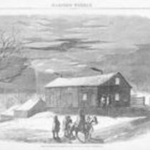
The Governor's Mansion, Lecompton, Kansas Territory
-
Description
-
Harper's Weekly wood engraving of men on horseback outside of the governor's mansion in Lecompton, Kansas Territory. The house was built by Douglas County Sheriff Samuel J. Jones and briefly resided in by Kansas Territorial Governor John W. Geary. In 1855, The "Bogus Legislature" selected the proslavery town of Lecompton as Kansas Territory's capital city. Meanwhile, Free-Staters continued to denounce the legislature as illegitimate.
-
Object Type
-
Image
-
Date
-
June 6, 1857
-
-
Title
-
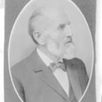
Daniel Read Anthony
-
Description
-
This black and white photograph shows Daniel Read Anthony, (1824-1904), brother of suffragist Susan B. Anthony. He migrated to the Kansas territory in 1854 as a member of the New England Emigrant Aid Company and settled in Leavenworth, Kansas; where he established a long and successfully career as a newspaper editor and publisher.
-
Object Type
-
Image
-
Date
-
1880-1904
-
-
Title
-
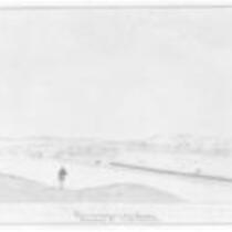
View of Manhattan, Kansas
-
Description
-
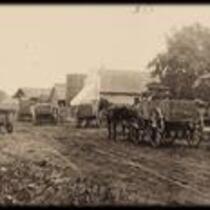
A civil war drawing by John Gaddis of the 12th Regt. Wisconsin Volunteers on their way to Ft. Riley, Kansas, near Manhattan, Kansas.
-
Object Type
-
Image
-
Date
-
April 24, 1862
-
-
Title
-
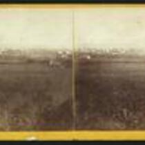
Fort Riley
-
Description
-
This stereograph of Fort Riley, Kansas was taken by Alexander Gardner. Gardner titles the image, "Fort Riley. No longer an outpost, Kansas. 420 miles west of St. Louis, Mo."
-
Object Type
-
Image
-
Date
-
1867
-

-
Title
-
Pottawatomie Creek
-
Description
-
Photograph of Pottawatomie Creek in Franklin County, Kansas.
-
Object Type
-
Image
-
-
Title
-
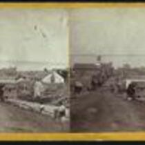
Fifth Street, Leavenworth, Kansas
-
Description
-
This stereograph of Leavenworth, Kansas was taken by Alexander Gardner. Gardner titles the image, "Fifth Street, Leavenworth, Kansas, 809 [309] miles west of St. Louis, Mo."
-
Object Type
-
Image
-
Date
-
1867
-
-
Title
-
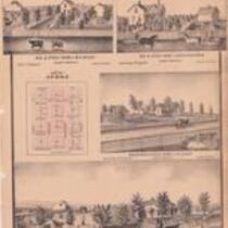
Plat and drawings of Aubry, Johnson County, Kansas
-
Description
-
This page from an 1874 plat book of Johnson County, Kansas includes a map of Aubry, Kansas and drawings of four Aubry Township residencies and stock farms, owned by W. H. Brady, John H. Troutman, J. H. Lusher, and E. F. Thompson.
-
Object Type
-
Image
-
Date
-
1874
-
-
Title
-
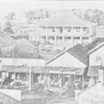
Market Street, Fort Scott, Kansas
-
Description
-
1863 photograph of Market Street with hospital in background; Fort Scott, Kansas. As early as August of 1861, the Union Army occupied this former frontier hospital after the fort closed in 1853.
-
Object Type
-
Image
-
Date
-
1863
-
-
Title
-
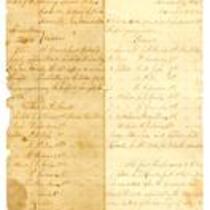
Court Martial Proceedings of Captain Lyman D. Rouell
-
Description
-
This military document includes proceedings of the general court martial of Lyman D. Rouell, Captain of the 2nd Colorado Volunteers, Company F. In this court martial held at the Headquarters District of the Border in Kansas City, Missouri, Captain Rouell pleads "not guilty" to: charges of drunkenness while on duty at Fort Lyon in the Colorado Territory and at Council Grove, Kansas; and for driving contraband stock into Kansas from Hickman Mills, Missouri. The official charges included "Conduct unbecoming an Officer and Gentlemen" and "Neglect of duty to the prejudices of good order and military discipline." The verdict is not extant. This document shows how some military units took advantage of General Ewing's General Order No. 11 by accumulating and selling property from abandoned counties.
-
Date
-
November 1863 - December 1863
-
-
Title
-
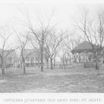
Fort Scott Army Post, Officers Quarters
-
Description
-
The Fort Scott officers quarters were constructed between 1842 to 1848. Army officers and their families who were posted at Fort Scott lived in the quarters.
-
Object Type
-
Image
-
Date
-
1890-1900
-
-
Title
-
Riley Street, Easton, Kansas
-
Description
-
The main street in Easton, Leavenworth County, Kansas, circa early 1900's.
-
Object Type
-
Image
-
Date
-
n.d.
-
-
Title
-
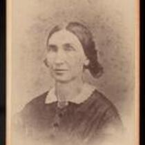
Florella Brown Adair
-
Description
-
Florella Brown Adair was the wife of Samuel Lyle Adair and the half-sister of abolitionist, John Brown. She settled near Osawatomie, Kansas Territory, with her husband, who was a Congregational minister. She and her husband were free state supporters. The identification on the photograph indicates it is an enlargement of a small photograph taken in 1862.
-
Object Type
-
Image
-
Date
-
1862
-
-
Title
-
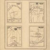
Battlegrounds of Price's Raid
-
Description
-
Maps of the battlefields at "Mine Creek, Oct. 22d 64," "Westport, Oct. 23d 64" "Charlot, Oct. 25th 64," and "Newtonia, Nov. 4th 64," showing the positions of troops, roads, drainage, a few houses, and relief by hachures. Charlot refers to "Charlot's Farm" near Richards, MO. This event is better known as the Battle of the Marmaton River. The Battle of Mine Creek took place south of Pleasanton, KS.
-
Date
-
1865
-
-
Title
-
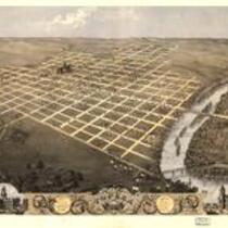
Topeka, Kansas
-
Description
-
Bird's eye view of the city of Topeka, the capital of Kansas, in 1869.
-
Object Type
-
Image
-
Date
-
1869
-

-
Title
-
Constitution Hall, Topeka, Kansas
-
Description
-
An illustration depicting the building where the Topeka Constitutional Convention met in 1855. Delegates assembled at Topeka on October 23, 1855, to draft a constitution. The document was approved on December 15 by a vote of 1,731 to 46. The proslavery--"Law and Order"--party did not participate in the voting on the document. Although Congress rejected this constitution and the request for admission to the Union, the Topeka government kept operating even though its legislature was closed down by U. S. troops on July 4, 1856. This building housed the Kansas legislature in 1864-1869 while the east wing of the state capitol was being built.
-
Object Type
-
Image
-
Date
-
1855
-
-
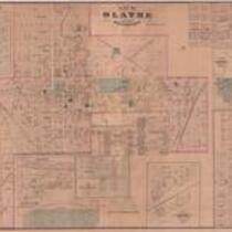
Title
-
Plats of Olathe, Gardner, Shawnee, Lenexa, et al., Johnson County, Kansas
-
Description
-
This page from an 1874 plat book of Johnson County, Kansas includes maps of Olathe, Gardner, Shawnee, Glenwood, Campbellton, Edgerton, Lenexa, Stanley, De Soto, and Olathe Junction.
-
Date
-
1874
-
-
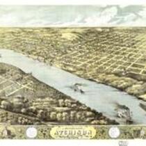
Title
-
Atchison, Kansas
-
Description
-
Bird's eye view of the city of Atchison, Atchison Co., Kansas in 1869.
-
Object Type
-
Image
-
Date
-
1869
Pages