Error message
Notice: Trying to access array offset on value of type null in IslandoraSolrDisplayManagerResults->currentQueryDisplays() (line 222 of /var/www/drupal7/sites/all/modules/islandora_solr_display_manager/includes/islandora_solr_display_manager.inc).
Pages
-
-
Title
-
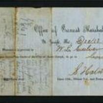
Pass for W.L. Culver
-
Description
-
This document from the Office of the Provost Marshal in St. Joseph, Missouri grants permission to W.L. Culver to leave the city limits. It is signed December 13, 1861 by S. Hatch, Provost Marshal. The reverse side of the document shows a printed oath, signed by Culver, that declares loyalty to both the federal government and the provisional government of Missouri. It describes Culver as a 26 year old man with “red whiskers”.
-
Object Type
-
Government Document
-
Date
-
December 13, 1861
-
-
Title
-
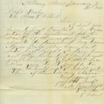
From H.M. Rice to William Fowler
-
Description
-
On January 21, 1865, H.M. Rice, Deputy Provost Marshal, 7th District Missouri, writes from Albany, Missouri to Capt. William Fowler, Provost Marshal, 7th District Missouri. Rice states that he is forwarding the corrected enrollment lists for Gentry County, Missouri. He adds that "Negro Culp" has been seen in the area, possibly on his way to St. Joseph, Missouri "to give himself up." "I will get him if there is any chance," Rice concludes.
-
Date
-
January 21, 1865
-
-
Title
-
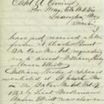
From J.W. Black to A. Comingo
-
Description
-
On December 14, 1863, J.W. Black, Deputy Provost Marshal for Ray County, Missouri, writes from Richmond, Missouri to Capt. A. Comingo, Provost Marshal for the 6th District of Missouri, in Lexington, Missouri. Black thanks Comingo for securing his new appointment as Recruiting Agent. He says he assumes Comingo is "annoyed very much with persons from our side of the river applying to you to be stricken from the enrollment list," and reports that he has already prevented many men from doing so.
-
Date
-
December 14, 1863
-

-
Title
-
From E.B. Alexander to William Fowler
-
Description
-
On August 8, 1863, Col. E.B. Alexander, Acting Assistant Provost Marshal General in St. Louis, writes to Capt. William Fowler, Provost Marshal for the 7th District of Missouri. Alexander reports that four "desperate" horse thieves have escaped from a court house in Iowa and are rumored to be in northern Missouri. He adds that one of the men, Washington Rodgers, is charged with enlisting men for the Confederate side "and is supposed to have been an active guerrilla in northern Missouri."
-
Date
-
August 8, 1863
-
-
Title
-
Discharge Papers of Lawrence Shannon
-
Description
-
This document certifies that Lawrence Shannon was discharged from the United States military on October 29, 1861 in St. Joseph, Missouri. The document describes Shannon as a 30-year old stone mason from Ireland. It states that Shannon was captured during the Battle of Lexington and mustered out of service per General Order No. 13. The document is signed by Capt. William Millar and Maj. R.T. Van Horn.
-
Date
-
October 29, 1861
-
-
Title
-
From E.S. Dulin to Jonathan B. Fuller
-
Description
-
This letter, dated March 12, 1863, is from E.S. Dulin, a pastor in St. Joseph, Missouri, to Jonathan B. Fuller, a pastor in Kansas City, Missouri. Dulin describes his community as "worn down" and tells Fuller that "our young men & all others that can are leaving to get rid of being 'Conscripted.'"
-
Date
-
March 12, 1863
-
-
Title
-
From J.A. Hay to Jonathan B. Fuller
-
Description
-
This letter is from J.A. Hay, the uncle of President Lincoln's private secretary, to Rev. Jonathan B. Fuller, a pastor in Kansas City, Missouri. Hay writes from St. Joseph, Missouri on January 30, 1863 and asks Fuller to visit a church in that town. He tells Fuller that the pastor supports the Union and mentions that he was "much gratified to hear brother Doulin make an earnest prayer for our Government."
-
Date
-
January 30, 1863
-

-
Title
-
Sectional Map of Kansas Territory
-
Description
-
This color map, dated April 1857, is entitled "Sectional Map of Kansas Territory." It was drafted by C.P. Wiggin and signed by L.A. MacLean, Chief Clerk of the Surveyor General’s office in Lecompton, Kansas Territory. MacLean certifies that the map was compiled from U.S. survey field notes. The map was published by MacLean and Lawrence and printed by William Schuchman and Bro. in Philadelphia.
-
Object Type
-
Map
-
Date
-
April 1857
-

-
Title
-
Nebraska and Kanzas
-
Description
-
This color map, ca. 1854-1861, is entitled “Nebraska and Kanzas.” It was printed by J.H. Colton and Co. in New York.
-
Object Type
-
Map
-
Date
-
1854-1861
-

-
Title
-
New Sectional Map of Kansas
-
Description
-
This color map, drafted in 1859 by Robert L. Ream, was published by Stevenson and Morris of St. Louis, and printed by A. Janicke and Co. of St. Louis. The map is entitled “New Sectional Map of Kansas,” and was compiled from the field notes in the Surveyor General’s office.
-
Object Type
-
Map
-
Date
-
1859
-
-
Title
-
From A.J. Huntoon to My Dear Wife
-
Description
-
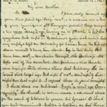
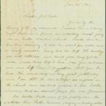
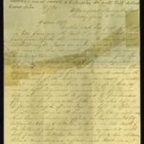
A.J. Huntoon writes a letter from Williamsport in Shawnee County, Kansas to his wife Lizzie, reporting that Rebels have fired at U.S. troops in Independence, Missouri. He adds that hundreds of Kansas troops have left Lawrence and Fort Leavenworth to assist U.S. troops in Kansas City and St. Joseph, Missouri. The letter, dated June 16 and 19, 1861, also mentions recent shootings in Leavenworth and Atchison, Kansas. Huntoon writes, “We may look for these as common occurrences in Kansas, for a while at least. All carry arms now . . . Men are paying out their last cent for them.”
-
Date
-
June 16, 1861-June 19, 1861
-

-
Title
-
Map Showing the Progress of the Public Surveys in the Territories of Kansas and Nebraska
-
Description
-
This black-and-white map, signed by Ward B. Burnett, Surveyor General, was issued by the Surveyor General’s office in Nebraska City, Nebraska Territory on October 1, 1860. The map shows the progress of the public surveys in the territories of Kansas and Nebraska, and was produced to accompany the Surveyor General’s 1860 annual report.
-
Object Type
-
Map
-
Date
-
October 1, 1860
-

-
Title
-
Map Showing the Progress of the Public Surveys in the Territories of Kansas and Nebraska
-
Description
-
This black-and-white map, signed by Ward B. Burnett, Surveyor General, was issued by the Surveyor General’s office in Nebraska City, Nebraska Territory on October 1, 1859. The map shows the progress of the public surveys in the territories of Kansas and Nebraska, and was produced to accompany the Surveyor General’s 1859 annual report.
-
Object Type
-
Map
-
Date
-
October 1, 1859
-

-
Title
-
Map Showing the Progress of the Public Surveys in Kansas and Nebraska
-
Description
-
This black-and-white map, signed by Mark W. Delahay, Surveyor General, was issued by the Surveyor General’s office in Leavenworth, Kansas on September 2, 1861. The map shows the progress of the public surveys in Kansas and Nebraska, and was produced to accompany the Surveyor General’s report of 1861.
-
Object Type
-
Map
-
Date
-
September 2, 1861
-

-
Title
-
Map Showing the Progress of the Public Surveys in the Territories of Kansas and Nebraska
-
Description
-
This black-and-white map, signed by Ward B. Burnett, Surveyor General, was issued by the Surveyor General’s office in Nebraska City, Nebraska Territory on October 1, 1858. The map depicts the progress of the public surveys in Kansas and Nebraska in 1858, and was created to accompany the Surveyor General's report of that year. The map was printed by C.B. Graham Lithographers in Washington, DC.
-
Date
-
October 1, 1858
-

-
Title
-
Map Showing the Progress of the Public Surveys in the Territories of Kansas and Nebraska
-
Description
-
This black-and-white map, signed by J. Calhoun, Surveyor General, was issued by the Surveyor General’s office in Lecompton, Kansas Territory in October 1857. The map shows the progress of the public surveys in the territories of Kansas and Nebraska, and was produced to accompany the Surveyor General’s 1857 annual report.
-
Date
-
October 1857
Pages
