
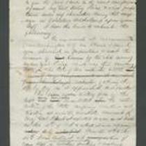
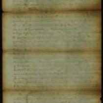
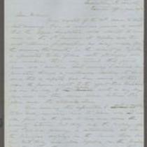
The missouri-kansas conflict 1854-1865
Error message
Notice: Trying to access array offset on value of type null in IslandoraSolrDisplayManagerResults->currentQueryDisplays() (line 222 of /var/www/drupal7/sites/all/modules/islandora_solr_display_manager/includes/islandora_solr_display_manager.inc).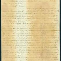


Object Type
- Letter (11)
- Map (10)
- Image (8)
- Government Document (4)
- Newspaper Article (3)
- Petition (3)
- Telegram (3)
- Document (2)
- Broadside (1)
- Legal Document (1)
- Pamphlet (1)
Local Subject
- Bleeding Kansas, Bloodletting Missouri (62)
- Battle for Missouri, 1861-1865 -- Military History of Missouri and Kansas (59)
- Kansas military units (58)
- Guerrillas (44)
- Surviving a Guerrilla War (30)
- American Indians (24)
- Picturing the War (21)
- African Americans (19)
- Women (15)
- Bushwhackers (11)
- Jayhawkers (11)
- Missouri military units (Union) (11)
- Border Ruffians (10)
- Missouri military units (Confederate) (8)
- Quantrill's Raid on Lawrence (8)
- Presidential Election of 1860, Secession, and the War's Commencement (6)
- Popular Sovereignty (5)
- Kansas-Nebraska Act (3)
- Lecompton Constitutional Convention (3)
- Bogus Legislature (2)
- Out-of-state military units serving in Missouri (2)
- Battle of Fort Titus (1)
- Battle of Hemp Bales / Battle of Lexington (1)
- Battle of Independence (Second) (1)
- Battle of Westport (1)
- Missouri Expedition / Price's Raid (1)
- Pottawatomie Massacre (1)
- Sack of Lawrence (First) (1)
- Topeka Constitutional Convention (1)
People
- James Henry Lane (20)
- Wilson Shannon (15)
- John W Geary (13)
- William Clarke Quantrill (8)
- Charles R Jennison (6)
- Charles Robinson (6)
- Franklin Pierce (6)
- J. McCahon (5)
- Samuel J Jones (5)
- Thomas Carney (5)
- Abraham Lincoln (4)
- Daniel R Anthony (4)
- Edward Fitch (4)
- Frederick Starr (4)
- James Gillpatrick Blunt (4)
- John Brown (4)
- Samuel R Curtis (4)
- Thomas E Ewing (4)
- --> (3)
- Daniel R. Anthony (3)
- Daniel Woodson (3)
- J. Calhoun (3)
- James Montgomery (3)
- R.H. Kimball & Company (photographers) (3)
- Samuel Lecompte (3)
- William Murphy (3)
- A.C. Nichols (photographer) (2)
- A.G. Boone (2)
- Andrew Reeder (2)
- Claiborne Fox Jackson (2)
- Cyrus Leland, Jr. (2)
- D.R. Atchison (2)
- David R Atchison (2)
- G.A. Parsons (2)
- George Collamore (2)
- H. Miles Moore (2)
- Hamilton R Gamble (2)
- James B. Fry (2)
- James H. Lane (2)
- Jefferson Davis (2)
- John A. Halderman (2)
- Joseph C. Anderson (2)
- Joseph H. Trego (2)
- Leigh R. Webber (2)
- Marcus J. Parrott (2)
- Mark W. Delahay (2)
- Sidney Clarke (2)
- Sterling Price (2)
- W.E. Prince (2)
- W.H. Russell (2)
Geographic Subject
- Leavenworth County, Kansas (131)
- Leavenworth, Kansas (101)
- Fort Leavenworth, Kansas (61)
- Douglas County, Kansas (57)
- Lawrence, Kansas (43)
- Lecompton, Kansas (33)
- Kansas City, Missouri (25)
- Jackson County, Missouri (24)
- Shawnee County, Kansas (24)
- Topeka, Kansas (22)
- Bourbon County, Kansas (17)
- Atchison County, Kansas (16)
- Fort Scott, Kansas (16)
- Atchison, Kansas (15)
- Wyandotte County, Kansas (14)
- Doniphan County, Kansas (13)
- Lafayette County, Missouri (13)
- Buchanan County, Missouri (11)
- Lexington, Missouri (11)
- St. Joseph, Missouri (11)
- Platte County, Missouri (10)
- Weston, Missouri (10)
- Clay County, Missouri (9)
- Franklin County, Kansas (9)
- Independence, Missouri (9)
- Johnson County, Kansas (9)
- Linn County, Kansas (9)
- Miami County, Kansas (9)
- Jefferson County, Kansas (7)
- Jackson County, Kansas (6)
- Liberty, Missouri (5)
- Cass County, Missouri (4)
- Fort Riley, Kansas (4)
- Quindaro, Kansas (4)
- Ray County, Missouri (4)
- Bates County, Missouri (3)
- Carroll County, Missouri (3)
- Johnson County, Missouri (3)
- Linn County, Missouri (3)
- Saline County, Missouri (3)
- Brown County, Kansas (2)
- Chariton County, Missouri (2)
- Henry County, Missoui (2)
- Riley County, Kansas (2)
- Andrew County, Missouri (1)
- Atchison County, Missouri (1)
- Caldwell County, Missouri (1)
- Cooper County, Missouri (1)
- Dekalb County, Missouri (1)
- Harrison County, Missouri (1)
Owning Organization
- Kansas Historical Society (70)
- National Archives at Kansas City (13)
- Lecompton Historical Society (12)
- Missouri Historical Society Library and Research Center (8)
- Kenneth Spencer Research Library (7)
- State Historical Society of Missouri – Columbia (6)
- Watkins Community Museum of History (4)
- Missouri State Archives (3)
- State Historical Society of Missouri – Kansas City (3)
- Library of Congress Prints and Photographs Division (2)
- Bates County Historical Society (1)
- Charles F. Curry Library, William Jewell College (1)
- Jackson County Records Center (1)