Error message
Notice: Trying to access array offset on value of type null in IslandoraSolrDisplayManagerResults->currentQueryDisplays() (line 222 of /var/www/drupal7/sites/all/modules/islandora_solr_display_manager/includes/islandora_solr_display_manager.inc).
-
-
Title
-
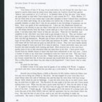
From Edward Fitch to Dear Parents
-
Description
-
Edward Fitch of Lawrence, Kansas writes a letter on August 25, 1856 to his parents, who live in Hopkinton, Massachusetts. Edward argues that Hopkinton, his hometown, should pay him for his contributions to the Free State cause in Kansas. He adds that a lot of his neighbors also need financial help and don’t have enough food or clothing. He writes that he recently attended the funeral of Captain Shombre, who was fatally wounded at the Battle of Fort Titus, and mentions that Major David S. Hoyt was killed the same week in an attack at Washington Creek.
-
Object Type
-
Letter
-
Date
-
August 25, 1856
-
-
Title
-
Statement of Wilson Shannon
-
Description
-
This statement by Kansas Gov. Wilson Shannon was written ca. December 1855. Shannon describes the series of events leading to the Wakarusa War, beginning with the murder of a Free State supporter named Charles Dow by Franklin Coleman, a proslavery man. To address the subsequent civil unrest in Douglas County, Kansas, Shannon asks General Richardson, General Strickler, and Col. Sumner to supply troops and assist Douglas County Sheriff Samuel J. Jones in restoring order.
-
Object Type
-
Government Document
-

-
Title
-
Nebraska and Kanzas
-
Description
-
This color map, ca. 1854-1861, is entitled “Nebraska and Kanzas.” It was printed by J.H. Colton and Co. in New York.
-
Object Type
-
Map
-
Date
-
1854-1861
-

-
Title
-
New Sectional Map of Kansas
-
Description
-
This color map, drafted in 1859 by Robert L. Ream, was published by Stevenson and Morris of St. Louis, and printed by A. Janicke and Co. of St. Louis. The map is entitled “New Sectional Map of Kansas,” and was compiled from the field notes in the Surveyor General’s office.
-
Object Type
-
Map
-
Date
-
1859
-

-
Title
-
Sectional Map of the Territory of Kansas
-
Description
-
This color map, entitled “Sectional Map of the Territory of Kansas,” was compiled from the field notes in the Surveyor General’s office. It was published in 1857 by John Halsall in St. Louis.
-
Object Type
-
Map
-
Date
-
1857
-

-
Title
-
Map Showing the Progress of the Public Surveys in the Territories of Kansas and Nebraska
-
Description
-
This black-and-white map, signed by Ward B. Burnett, Surveyor General, was issued by the Surveyor General’s office in Nebraska City, Nebraska Territory on October 1, 1860. The map shows the progress of the public surveys in the territories of Kansas and Nebraska, and was produced to accompany the Surveyor General’s 1860 annual report.
-
Object Type
-
Map
-
Date
-
October 1, 1860
-

-
Title
-
Map Showing the Progress of the Public Surveys in the Territories of Kansas and Nebraska
-
Description
-
This black-and-white map, signed by Ward B. Burnett, Surveyor General, was issued by the Surveyor General’s office in Nebraska City, Nebraska Territory on October 1, 1859. The map shows the progress of the public surveys in the territories of Kansas and Nebraska, and was produced to accompany the Surveyor General’s 1859 annual report.
-
Object Type
-
Map
-
Date
-
October 1, 1859
-

-
Title
-
Map Showing the Progress of the Public Surveys in the Territories of Kansas and Nebraska
-
Description
-
This black-and-white map, signed by J. Calhoun, Surveyor General, was issued by the Surveyor General’s office in Lecompton, Kansas Territory in October 1857. The map shows the progress of the public surveys in the territories of Kansas and Nebraska, and was produced to accompany the Surveyor General’s 1857 annual report.
-
Date
-
October 1857
