Error message
Notice: Trying to access array offset on value of type null in IslandoraSolrDisplayManagerResults->currentQueryDisplays() (line 222 of /var/www/drupal7/sites/all/modules/islandora_solr_display_manager/includes/islandora_solr_display_manager.inc).
-
-
Title
-
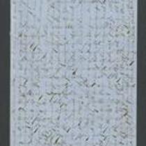
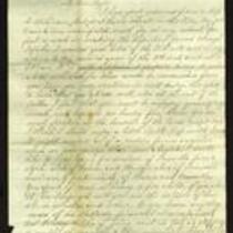
From James Griffing to Unknown
-
Description
-
This letter, dated January 10, 1854 but presumably written January 10, 1855, was sent by James Griffing in Wyandotte County, Kansas to an unknown recipient. James discusses pioneer life in Kansas Territory, claiming that it is not at all dangerous: “Our society is mostly all from the East, and you feel just as much composed as when in New England.” Although James believes Missourians are more dangerous than the American Indians, he insists “there is no more reason for a person who attends to his own business to be afraid here” than anywhere else.
-
Date
-
January 10, 1855
-
-
Title
-
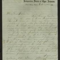
From A.J. Huntoon to My Dear Lizzie
-
Description
-
A.J. Huntoon writes a letter from Williamsport in Shawnee County, Kansas to his wife Lizzie, announcing that the country is “in a state of great political excitement” following the seizure of Fort Sumter. The letter, dated April 19, 21, and 22, 1861, states that Confederate supporters tried to raise a Palmetto flag in St. Joseph, Missouri, but Union supporters stopped them. Huntoon informs his wife that militia companies are organizing in Kansas, and he asks her if she objects to him becoming an assistant surgeon for the army. He also relays the news that Gen. Lane has been placed in command of 1,000 men in Washington.
-
Date
-
April 19, 1861-April 22, 1861
-
-
Title
-
Diary of Lewis Timothy Litchfield
-
Description
-
This is an excerpt from the diary of Lewis Thomas Litchfield, written between 1854 and 1855. Litchfield writes about leaving Boston and travelling to Kansas with a party from the Emigrant Aid Society. He describes the pioneer camp established near the junction of the Kansas and Wakarusa Rivers, voting to name the settlement "Lawrence," and construction of the first building. Litchfield also mentions a burgeoning conflict between the Kansas settlers and the Missourians.
-
Object Type
-
Diary
-
Date
-
1854-1855
-

-
Title
-
From Julia Mariata to Unknown
-
Description
-
In this October 5, 1856 letter, Julia Mariata describes the arrest and capture of her brother-in-law, H. Miles Moore. On October 2, Mariata says, she and Moore left Lawrence, Kansas and stopped at the American Hotel in Kansas City, Missouri, where Moore was arrested and taken away by a group of men. A Mr. King told Mariata that Moore was arrested because he had served as Adjutant General under Gen. Lane, and that “he was considered guilty of High Treason!”
-
Date
-
October 5, 1856
-
-
Title
-
From Samuel Worthington to My Dear Father
-
Description
-
Samuel Worthington writes a letter from Fort Riley, Kansas to his father on October 12, 1864. He has just received news that Gen. Price is advancing his forces, and he expresses fear that Kansas does not have enough troops to defeat him. He also mentions the possibility of a new treaty with the Indians. In a postscript, Worthington reports that Rebels have just arrived in Kansas City, and tells his father “goodbye—If I dont return remember I fought for the right.”
-
Date
-
October 12, 1864
-
-
Title
-
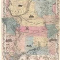
Nebraska and Kansas
-
Description
-
This color map, entitled “Nebraska and Kansas,” shows those two territories, the territory acquired from Mexico in 1854, and a small map of the continental United States. The map was published in 1854 by J.H. Colton and Co. in New York.
-
Object Type
-
Map
-
Date
-
1854
-
-
Title
-
Affidavit of Henry E. McKee
-
Description
-
This is the sworn affidavit of Henry E. McKee, signed by Kansas Gov. John W. Geary on October 4, 1856. McKee claims that on October 2, he witnessed H. Miles Moore enter the American Hotel in Kansas City, Missouri, where eight men captured him. They took Moore to Wyandotte, Kansas and “unlawfully imprisoned” him there, McKee says. He adds that if Moore does not receive help soon, “his life is in great hazard and will be sacrificed.”
-
Object Type
-
Legal Document
-
Date
-
October 4, 1856
-

-
Title
-
Sectional Map of Kansas Territory
-
Description
-
This color map, dated April 1857, is entitled "Sectional Map of Kansas Territory." It was drafted by C.P. Wiggin and signed by L.A. MacLean, Chief Clerk of the Surveyor General’s office in Lecompton, Kansas Territory. MacLean certifies that the map was compiled from U.S. survey field notes. The map was published by MacLean and Lawrence and printed by William Schuchman and Bro. in Philadelphia.
-
Object Type
-
Map
-
Date
-
April 1857
-

-
Title
-
Nebraska and Kanzas
-
Description
-
This color map, ca. 1854-1861, is entitled “Nebraska and Kanzas.” It was printed by J.H. Colton and Co. in New York.
-
Object Type
-
Map
-
Date
-
1854-1861
-

-
Title
-
New Sectional Map of Kansas
-
Description
-
This color map, drafted in 1859 by Robert L. Ream, was published by Stevenson and Morris of St. Louis, and printed by A. Janicke and Co. of St. Louis. The map is entitled “New Sectional Map of Kansas,” and was compiled from the field notes in the Surveyor General’s office.
-
Object Type
-
Map
-
Date
-
1859
-

-
Title
-
Sectional Map of the Territory of Kansas
-
Description
-
This color map, entitled “Sectional Map of the Territory of Kansas,” was compiled from the field notes in the Surveyor General’s office. It was published in 1857 by John Halsall in St. Louis.
-
Object Type
-
Map
-
Date
-
1857
-
-
Title
-
From Fred to Dear Cousins
-
Description
-
This February 28, 1862 letter is from a soldier named Fred to his cousins. He reports that he just marched from Fort Leavenworth, Kansas with Company A, to Kansas City, Missouri, where they are guarding Fort Union against the Jayhawkers. He tells his cousins that the 2nd Battalion of his regiment "had a brush with the rebels at Independence," and adds that he may be marching to St. Louis soon.
-
Date
-
February 28, 1862
-

-
Title
-
Map Showing the Progress of the Public Surveys in the Territories of Kansas and Nebraska
-
Description
-
This black-and-white map, signed by Ward B. Burnett, Surveyor General, was issued by the Surveyor General’s office in Nebraska City, Nebraska Territory on October 1, 1860. The map shows the progress of the public surveys in the territories of Kansas and Nebraska, and was produced to accompany the Surveyor General’s 1860 annual report.
-
Object Type
-
Map
-
Date
-
October 1, 1860
-

-
Title
-
Map Showing the Progress of the Public Surveys in the Territories of Kansas and Nebraska
-
Description
-
This black-and-white map, signed by Ward B. Burnett, Surveyor General, was issued by the Surveyor General’s office in Nebraska City, Nebraska Territory on October 1, 1859. The map shows the progress of the public surveys in the territories of Kansas and Nebraska, and was produced to accompany the Surveyor General’s 1859 annual report.
-
Object Type
-
Map
-
Date
-
October 1, 1859
-

-
Title
-
Map Showing the Progress of the Public Surveys in Kansas and Nebraska
-
Description
-
This black-and-white map, signed by Mark W. Delahay, Surveyor General, was issued by the Surveyor General’s office in Leavenworth, Kansas on September 2, 1861. The map shows the progress of the public surveys in Kansas and Nebraska, and was produced to accompany the Surveyor General’s report of 1861.
-
Object Type
-
Map
-
Date
-
September 2, 1861
-

-
Title
-
Map Showing the Progress of the Public Surveys in the Territories of Kansas and Nebraska
-
Description
-
This black-and-white map, signed by Ward B. Burnett, Surveyor General, was issued by the Surveyor General’s office in Nebraska City, Nebraska Territory on October 1, 1858. The map depicts the progress of the public surveys in Kansas and Nebraska in 1858, and was created to accompany the Surveyor General's report of that year. The map was printed by C.B. Graham Lithographers in Washington, DC.
-
Date
-
October 1, 1858
-

-
Title
-
Map Showing the Progress of the Public Surveys in the Territories of Kansas and Nebraska
-
Description
-
This black-and-white map, signed by J. Calhoun, Surveyor General, was issued by the Surveyor General’s office in Lecompton, Kansas Territory in October 1857. The map shows the progress of the public surveys in the territories of Kansas and Nebraska, and was produced to accompany the Surveyor General’s 1857 annual report.
-
Date
-
October 1857
