Error message
Notice: Trying to access array offset on value of type null in IslandoraSolrDisplayManagerResults->currentQueryDisplays() (line 222 of /var/www/drupal7/sites/all/modules/islandora_solr_display_manager/includes/islandora_solr_display_manager.inc).
Pages
-
-
Title
-
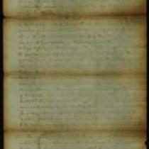
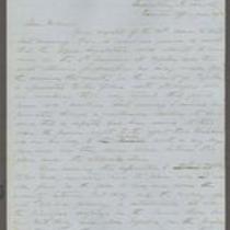
From James H. Lane to E.M. Stanton
-
Description
-
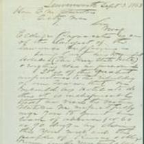
On September 3, 1863, James H. Lane writes from Leavenworth, Kansas to Secretary of War E.M. Stanton. Lane states that as Col. S.W. Eldridge has suffered greatly from the loss of The Free State Hotel in Lawrence, Kansas, during Quantrill's Raid on the town, he should be granted a leave of absence to travel east, presumably to appeal for aid in rebuilding the hotel.
-
Object Type
-
Letter
-
Date
-
September 3, 1863
-
-
Title
-
From James H. Lane et al to "All Whom It May Concern"
-
Description
-
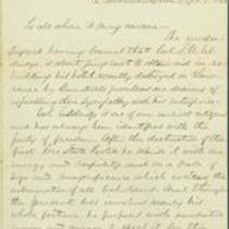
On September 5, 1863, James H. Lane and five others write an open letter from Leavenworth, Kansas to "all whom it may concern." Lane and the others express sympathy with Col. S.W. Eldridge, who is travelling east to seek aid in rebuilding the Free State Hotel in Lawrence, Kansas, which was destroyed during Quantrill's Raid. The signers assure potential contributors to Eldridge's project that he is "a man in every respect worthy of their full confidence."
-
Date
-
September 5, 1863
-
-
Title
-
From S.C. Pomeroy to Col. S.W. Eldridge
-
Description
-
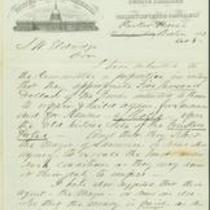
On October 8, 1863, S.C. Pomeroy writes from Parker House, Boston to Col. S.W. Eldridge. Pomeroy states that he submitted a proposal to "the Committee" to appropriate $5,000 in funds for rebuilding the destroyed Free State Hotel in Lawrence, Kansas. Pomeroy also proposes that once the hotel is rebuilt, the Mayor of Lawrence should assign a portion of the donated money to assist families affected by the raid. Pomeroy notes, "This last provision sweetens the thing--and I have little doubt that it will pass."
-
Date
-
October 8, 1863
-
-
Title
-
From George D. Bayard to Father
-
Description
-
This is a copy of an October 1, 1856 letter from George D. Bayard in Fort Leavenworth, Kansas to his father. Bayard tells his father that Kansas is overrun with invaders from Missouri who want to make it a slave state, and with northern emigrants who want to make it a free state. He criticizes Gov. John W. Geary for not taking a strong stand against slavery. He also mentions that troops from Lecompton are pursuing James Henry Lane and his men.
-
Date
-
October 1, 1856
-
-
Title
-
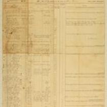
Muster Rolls of Kansas Volunteer Regiments
-
Description
-
These muster rolls from 1861 and 1862 list the names, ranks, and enrollment dates of soldiers in companies from the 4th and 10th Kansas Volunteer Regiments. They also list the names of soldiers who deserted their regiments or were discharged, transferred, or deceased. The companies were commanded by Capt. James M. Harvey, Capt. James H. Harris, Col. William Weir, and Col. William Cloud.
-
Date
-
1861-1862
-
-
Title
-
From Edward Fitch to Dear Parents
-
Description
-
In an April 28, 1861 letter to his parents in Massachusetts, Edward Fitch of Lawrence, Kansas declares, “did you think that you would ever live to see it—a Civil War, the most horrible of all wars.” He informs them that he has joined an artillery company. He adds that the military “is organising in large numbers” in Lawrence, but he expresses his fear that if Missouri secedes from the Union, Kansas will not have enough arms or ammunition for defense. He also expresses concern that the Cherokee and Choctaw tribes will fight for the South.
-
Date
-
April 28, 1861
-

-
Title
-
Sectional Map of Kansas Territory
-
Description
-
This color map, dated April 1857, is entitled "Sectional Map of Kansas Territory." It was drafted by C.P. Wiggin and signed by L.A. MacLean, Chief Clerk of the Surveyor General’s office in Lecompton, Kansas Territory. MacLean certifies that the map was compiled from U.S. survey field notes. The map was published by MacLean and Lawrence and printed by William Schuchman and Bro. in Philadelphia.
-
Object Type
-
Map
-
Date
-
April 1857
-
-
Title
-
From Persifor Smith to M.C. Dickey
-
Description
-
This letter, dated July 23, 1856, is from Persifor Smith, a U.S. Army Major at Fort Leavenworth, to M.C. Dickey and “others, conductors of emigrating companies.” Smith responds to a letter in which Dickey and the others request military protection from armed bodies guarding the Kansas border. Smith denies their request: “I have no evidence that any parties are in arms to oppose you . . . I cannot act on your vague suspicions.”
-
Object Type
-
Letter
-
Date
-
July 23, 1856
-

-
Title
-
New Sectional Map of Kansas
-
Description
-
This color map, drafted in 1859 by Robert L. Ream, was published by Stevenson and Morris of St. Louis, and printed by A. Janicke and Co. of St. Louis. The map is entitled “New Sectional Map of Kansas,” and was compiled from the field notes in the Surveyor General’s office.
-
Object Type
-
Map
-
Date
-
1859
-
-
Title
-
From A.J. Huntoon to My Dear Wife
-
Description
-
A.J. Huntoon writes a letter from Williamsport in Shawnee County, Kansas to his wife Lizzie, reporting that Rebels have fired at U.S. troops in Independence, Missouri. He adds that hundreds of Kansas troops have left Lawrence and Fort Leavenworth to assist U.S. troops in Kansas City and St. Joseph, Missouri. The letter, dated June 16 and 19, 1861, also mentions recent shootings in Leavenworth and Atchison, Kansas. Huntoon writes, “We may look for these as common occurrences in Kansas, for a while at least. All carry arms now . . . Men are paying out their last cent for them.”
-
Date
-
June 16, 1861-June 19, 1861
-

-
Title
-
From A.J. Sexton to Catherine
-
Description
-
This letter was written on April 6, 1862, by A.J. Sexton to his wife Catherine. A.J. states that his regiment is camped near Lawrence, Kansas and may go next to New Mexico. He writes about the health of the men in his regiment, mentioning several illnesses and deaths. A.J. says that he received two months’ pay the previous week, and plans to send $15.00 to Catherine by express. He asks Catherine if she has received any money from the state, and wants to know “how you get along for money.”
-
Date
-
April 6, 1862
-

-
Title
-
Sectional Map of the Territory of Kansas
-
Description
-
This color map, entitled “Sectional Map of the Territory of Kansas,” was compiled from the field notes in the Surveyor General’s office. It was published in 1857 by John Halsall in St. Louis.
-
Object Type
-
Map
-
Date
-
1857
-
-
Title
-
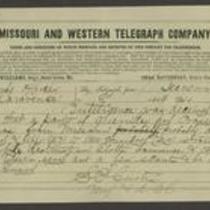
From Samuel R. Curtis to Edmund G. Ross
-
Description
-
This telegram, dated 1864, is from Major Samuel R. Curtis at Fort Leavenworth to Edmund G. Ross in Lawrence, Kansas. Curtis reports that 150-200 Missouri guerrillas have entered Kansas and are likely to invade Olathe, Lawrence, and Topeka. He tells Ross to warn Topeka of a possible attack and urges him to “be on your guard.”
-
Object Type
-
Telegram
-
Date
-
1864
-

-
Title
-
Map Showing the Progress of the Public Surveys in the Territories of Kansas and Nebraska
-
Description
-
This black-and-white map, signed by Ward B. Burnett, Surveyor General, was issued by the Surveyor General’s office in Nebraska City, Nebraska Territory on October 1, 1860. The map shows the progress of the public surveys in the territories of Kansas and Nebraska, and was produced to accompany the Surveyor General’s 1860 annual report.
-
Object Type
-
Map
-
Date
-
October 1, 1860
-

-
Title
-
Map Showing the Progress of the Public Surveys in the Territories of Kansas and Nebraska
-
Description
-
This black-and-white map, signed by Ward B. Burnett, Surveyor General, was issued by the Surveyor General’s office in Nebraska City, Nebraska Territory on October 1, 1859. The map shows the progress of the public surveys in the territories of Kansas and Nebraska, and was produced to accompany the Surveyor General’s 1859 annual report.
-
Object Type
-
Map
-
Date
-
October 1, 1859
-

-
Title
-
Map Showing the Progress of the Public Surveys in Kansas and Nebraska
-
Description
-
This black-and-white map, signed by Mark W. Delahay, Surveyor General, was issued by the Surveyor General’s office in Leavenworth, Kansas on September 2, 1861. The map shows the progress of the public surveys in Kansas and Nebraska, and was produced to accompany the Surveyor General’s report of 1861.
-
Object Type
-
Map
-
Date
-
September 2, 1861
-
-
Title
-
From Edward Hoogland and John A.W. Jones to John W. Geary
-
Description
-
In this November 29, 1856 letter, Edward Hoogland and John A.W. Jones report to Kansas Gov. John W. Geary about their recent expedition to southeastern Kansas. They inform Geary that they took depositions, issued warrants, and made arrests in relation to a number of crimes, including some committed during the Pottawatomie Massacre. They also report that they found and returned a substantial amount of stolen property. Hoogland and Jones ask Geary to station U.S. troops in southeastern Kansas, suggesting that “their presence would aid in restoring confidence.”
-
Date
-
November 29, 1856
-
-
Title
-
From Daniel Woodson to E.V. Sumner
-
Description
-
This dispatch, dated June 30, 1856, was sent by Acting Kansas Gov. Daniel Woodson in Lecompton, Kansas, to Col. E.V. Sumner at Fort Leavenworth, Kansas. Woodson states that the “bogus Legislature” of Free-Staters will undoubtedly meet at Topeka on July 4, 1856, and that Gen. Lane’s forces are believed to be approaching Topeka. Woodson has ordered Lt. Col. Philip St. George Cooke to secure the area between Fort Riley, Kansas, and Topeka. He instructs Sumner to go to Topeka personally with at least two more companies of U.S. troops.
-
Date
-
June 30, 1856
-
-
Title
-
From Leigh R. Webber to "Senorita Morena"
-
Description
-
This letter, dated April 30, 1862, is from Leigh R. Webber in "Camp of the Kansas First" to "Senorita Morena" (Miss Brown). Webber says his regiment is comfortably situated, and declares, "Fort Riley is not to be slurred at. It beats Fort Leavenworth all hollow, and Fort Scott is nowhere beside it." He reports that "We had a general inspection on Monday, and were mustered this forenoon," and adds that the soldiers will soon receive new equipment and arms.
-
Object Type
-
Letter
-
Date
-
April 30, 1862
-

-
Title
-
Map Showing the Progress of the Public Surveys in the Territories of Kansas and Nebraska
-
Description
-
This black-and-white map, signed by Ward B. Burnett, Surveyor General, was issued by the Surveyor General’s office in Nebraska City, Nebraska Territory on October 1, 1858. The map depicts the progress of the public surveys in Kansas and Nebraska in 1858, and was created to accompany the Surveyor General's report of that year. The map was printed by C.B. Graham Lithographers in Washington, DC.
-
Date
-
October 1, 1858
Pages
