
The missouri-kansas conflict 1854-1865
Error message
Notice: Trying to access array offset on value of type null in IslandoraSolrDisplayManagerResults->currentQueryDisplays() (line 222 of /var/www/drupal7/sites/all/modules/islandora_solr_display_manager/includes/islandora_solr_display_manager.inc).

Object Type
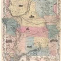
- Map (2)
- Government Document (1)
Local Subject
- Bleeding Kansas, Bloodletting Missouri (4)
- African Americans (2)
- Picturing the War (2)
- Battle for Missouri, 1861-1865 -- Military History of Missouri and Kansas (1)
- Battle of Hemp Bales / Battle of Lexington (1)
- Missouri military units (Confederate) (1)
- Out-of-state military units serving in Missouri (1)
- Presidential Election of 1860, Secession, and the War's Commencement (1)
- Surviving a Guerrilla War (1)
People
- "C." (1)
- David R. Atchison (1)
- Frederick Starr (1)
- J.G. Wells (Lithographer) (1)
- J.H. Colton and Co. (1)
- Sterling Price (1)
Geographic Subject
- Clay County, Missouri (5)
- Platte County, Missouri (4)
- Andrew County, Missouri (3)
- Atchison County, Missouri (3)
- Holt County, Missouri (3)
- Liberty, Missouri (3)
- Nodaway County, Missouri (3)
- Bates County, Missouri (2)
- Buchanan County, Missouri (2)
- Carroll County, Missouri (2)
- Cass County, Missouri (2)
- Chariton County, Missouri (2)
- Dekalb County, Missouri (2)
- Harrison County, Missouri (2)
- Henry County, Missoui (2)
- Jackson County, Missouri (2)
- Johnson County, Missouri (2)
- Lafayette County, Missouri (2)
- Leavenworth County, Kansas (2)
- Leavenworth, Kansas (2)
- Linn County, Missouri (2)
- Mercer County, Missouri (2)
- Ray County, Missouri (2)
- Vernon County, Missouri (2)
- Atchison County, Kansas (1)
- Bourbon County, Kansas (1)
- Caldwell County, Missouri (1)
- Clinton County, Missouri (1)
- Cooper County, Missouri (1)
- Doniphan County, Kansas (1)
- Douglas County, Kansas (1)
- Fort Leavenworth, Kansas (1)
- Fort Riley, Kansas (1)
- Fort Scott, Kansas (1)
- Franklin County, Kansas (1)
- Gentry County, Missouri (1)
- Grundy County, Missouri (1)
- Howard County, Missouri (1)
- Independence, Missouri (1)
- Jackson County, Kansas (1)
- Johnson County, Kansas (1)
- Kansas City, Missouri (1)
- Lawrence, Kansas (1)
- Lecompton, Kansas (1)
- Lexington, Missouri (1)
- Linn County, Kansas (1)
- Livingston County, Missouri (1)
- Putnam County, Missouri (1)
- Saline County, Missouri (1)
- Shawnee County, Kansas (1)