Error message
Notice: Trying to access array offset on value of type null in IslandoraSolrDisplayManagerResults->currentQueryDisplays() (line 222 of /var/www/drupal7/sites/all/modules/islandora_solr_display_manager/includes/islandora_solr_display_manager.inc).
-
-
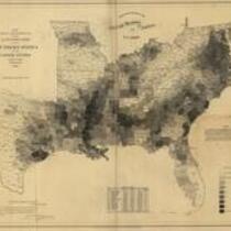
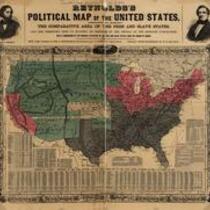
Title
-
Reynolds's Political Map of the United States
-
Description
-
Printed on map: "Designed to exhibit the comparative area of the free and slave states and the territory open to slavery or freedom by the repeal of the Missouri compromise. With a comparison of the principal statistics of the free and slave states, from the census of 1850." Political map delineating the slave states, free states, and open territories, ca. 1856. The maps were created as political propaganda for the first Republican Party candidate for President, John C. Fremont, whose likeness is visible in the upper left corner of the map.
-
Object Type
-
Map
-
-
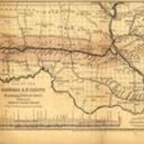
Title
-
Map of the Hannibal & St. Joseph Railroad
-
Description
-
Map of the Hannibal & St. Joseph Railroad, which was chartered in 1847 and completed in 1859. Map depicts northern Missouri and parts of Kansas and Illinois, showing rivers, settlements, railroads, and the land grant awarded to the Hannibal & St. Joseph Railroad.
-
Object Type
-
Map, Image