Error message
Notice: Trying to access array offset on value of type null in IslandoraSolrDisplayManagerResults->currentQueryDisplays() (line 222 of /var/www/drupal7/sites/all/modules/islandora_solr_display_manager/includes/islandora_solr_display_manager.inc).
-
-
Title
-
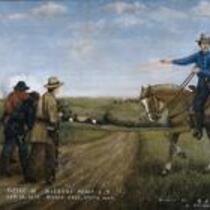
Battle of Hickory Point
-
Description
-
Painting by Samuel J. Reader depicting the Battle of Hickory Point. On September 13, 1856, James H. Lane led a force of jayhawkers against Hickory Point, a proslavery settlement in Jefferson County, Kansas that had supported an attack against Grasshopper Falls. Lane soon understood that he lacked artillery to attack the log buildings, and he retreated. During the retreat, Missourians pursued Lane's forces and attacked, but the jayhawkers returned fire. After receiving word that Territorial Governor John Geary had ordered a ceasefire, Lane withdrew, but reinforcements from Lawrence under command of Colonel James A. Harvey arrived on September 14, toting the captured cannon "Old Sacramento," and fired on the town. One proslavery man was killed, four others wounded, and several Free-Staters were wounded before a ceasefire was called and the Missourians withdrew from the area. 100 Free-Staters were arrested by U.S. troops, but they were later acquitted for acting in self-defense.
-
Object Type
-
Image
-

-
Title
-
Sectional Map of Kansas Territory
-
Description
-
This color map, dated April 1857, is entitled "Sectional Map of Kansas Territory." It was drafted by C.P. Wiggin and signed by L.A. MacLean, Chief Clerk of the Surveyor General’s office in Lecompton, Kansas Territory. MacLean certifies that the map was compiled from U.S. survey field notes. The map was published by MacLean and Lawrence and printed by William Schuchman and Bro. in Philadelphia.
-
Object Type
-
Map
-
Date
-
April 1857
