Error message
Notice: Trying to access array offset on value of type null in IslandoraSolrDisplayManagerResults->currentQueryDisplays() (line 222 of /var/www/drupal7/sites/all/modules/islandora_solr_display_manager/includes/islandora_solr_display_manager.inc).
-
-
Title
-
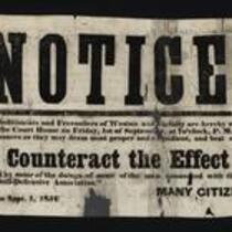
Notice! to Abolitionists and Freesoilers of Weston
-
Description
-
This broadside calls on “The Abolitionists and Freesoilers of Weston and vicinity” to meet at the Weston, Missouri courthouse on September 1, 1854 at 7:00pm, “to adopt such measures as they may deem most proper and expedient, and best calculated to Counteract the Effect produced by some of the doings of some of the men connected with the ‘Platte County Self-Defensive Association.’” The broadside was issued by “Many Citizens” on September 1, 1854 in Weston.
-
Object Type
-
Broadside
-
Date
-
September 1, 1854
-
-
Title
-
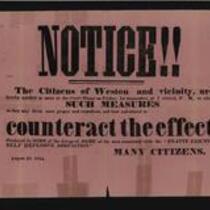
Notice! to Citizens of Weston
-
Description
-
This broadside calls on “The Citizens of Weston and vicinity” to meet at the Weston, Missouri courthouse on September 1, 1854 at 7:00pm, “to adopt such measures as they may deem most proper and expedient, and best calculated to counteract the effect produced by SOME of the doings of SOME of the men connected with the ‘PLATTE COUNTY SELF DEFENSIVE ASSOCIATION.’” The broadside is signed “Many Citizens,” and is dated August 31, 1854.
-
Object Type
-
Broadside
-
Date
-
August 31, 1854
-
-
Title
-
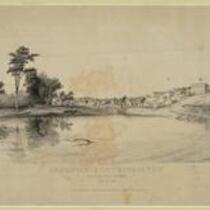
Leavenworth City, Kansas Territory
-
Description
-
Depiction of the city of Leavenworth, Kansas in 1856. Missourians from Weston, Missouri and residents of Fort Leavenworth founded the city in the fall of 1854.
-
Object Type
-
Image
-
Date
-
n.d.
-

-
Title
-
New Sectional Map of Kansas
-
Description
-
This color map, drafted in 1859 by Robert L. Ream, was published by Stevenson and Morris of St. Louis, and printed by A. Janicke and Co. of St. Louis. The map is entitled “New Sectional Map of Kansas,” and was compiled from the field notes in the Surveyor General’s office.
-
Object Type
-
Map
-
Date
-
1859
-

-
Title
-
Sectional Map of the Territory of Kansas
-
Description
-
This color map, entitled “Sectional Map of the Territory of Kansas,” was compiled from the field notes in the Surveyor General’s office. It was published in 1857 by John Halsall in St. Louis.
-
Object Type
-
Map
-
Date
-
1857
-

-
Title
-
Map Showing the Progress of the Public Surveys in the Territories of Kansas and Nebraska
-
Description
-
This black-and-white map, signed by J. Calhoun, Surveyor General, was issued by the Surveyor General’s office in Lecompton, Kansas Territory in October 1857. The map shows the progress of the public surveys in the territories of Kansas and Nebraska, and was produced to accompany the Surveyor General’s 1857 annual report.
-
Date
-
October 1857
