Error message
Notice: Trying to access array offset on value of type null in IslandoraSolrDisplayManagerResults->currentQueryDisplays() (line 222 of /var/www/drupal7/sites/all/modules/islandora_solr_display_manager/includes/islandora_solr_display_manager.inc).
-
-
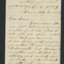
Title
-
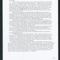
From Edward Fitch to Dear Mother
-
Description
-
This unsigned April 11, 1858 letter, presumably from Edward Fitch to his mother, discusses the immigrants living in Kansas Territory. The Irish immigrants, Fitch says, are predominantly pro-slavery, while the German immigrants are mostly supporters of the Free State Party. He also describes to his mother the spring flowers in Lawrence, Kansas and his beautiful baby.
-
Date
-
April 11, 1858
-
-
Title
-
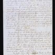
From Frederick Starr to My Dear Father
-
Description
-
On March 19, 1855, Frederick Starr writes from Weston, Missouri to his father. Starr transcribes a recent article from the local newspaper “Liberty Platform,” in which he is accused of being a “political priest” in charge of a “gang” of abolitionists. Starr believes the article makes unjust and false statements about him, but admits “it may be the impression which has fixed itself upon the minds of the fire eating part of the community. If so I would not have it otherwise.” The article also describes the nomination of Gen. Whitfield as the Kansas Territory delegate to Congress.
-
Date
-
March 19, 1855
-
-
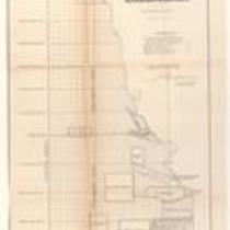
Title
-
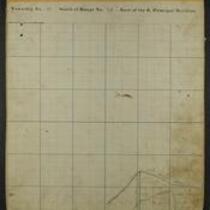
Maps of Shawnee Indian Reservation
-
Description
-
These 21 plat maps were made ca. 1857 by Isaac Cooper Stuck. The maps are marked with geographical features and locations of people’s land claims within the Shawnee Indian Reservation in eastern Kansas.
-
Object Type
-
Map
-
-
Title
-
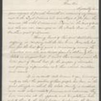
From George W. Collamore to William P. Dole
-
Description
-
This letter, dated April 21, 1862, is from George W. Collamore to Hon. William P. Dole, Commissioner of Indian Affairs. Writing from Washington, DC, Collamore provides an account of his "recent visit to the Loyal Indians who were obliged to flee from their pursuers (the rebel Indians and Texans) in the dead of Winter and are now encamped on the Neosho River" in southern Kansas. Collamore states that these Indians, numbering about 8,000, have suffered and many have died from exposure and lack of food.
-
Date
-
April 21, 1862
-
-
Title
-
Plan of the Public Surveys in Kansas and Nebraska
-
Description
-
This black-and-white map, signed by J. Calhoun, Surveyor General of Kansas and Nebraska, was issued by the Surveyor General’s office in Wyandott, Kansas Territory on October 20, 1856. The map is entitled "Plan of the Public Surveys in Kansas and Nebraska." It was printed by Ackerman Lithographers in New York.
-
Object Type
-
Map
-
Date
-
October 20, 1856
-

-
Title
-
Sectional Map of Kansas Territory
-
Description
-
This color map, dated April 1857, is entitled "Sectional Map of Kansas Territory." It was drafted by C.P. Wiggin and signed by L.A. MacLean, Chief Clerk of the Surveyor General’s office in Lecompton, Kansas Territory. MacLean certifies that the map was compiled from U.S. survey field notes. The map was published by MacLean and Lawrence and printed by William Schuchman and Bro. in Philadelphia.
-
Object Type
-
Map
-
Date
-
April 1857
-

-
Title
-
New Sectional Map of Kansas
-
Description
-
This color map, drafted in 1859 by Robert L. Ream, was published by Stevenson and Morris of St. Louis, and printed by A. Janicke and Co. of St. Louis. The map is entitled “New Sectional Map of Kansas,” and was compiled from the field notes in the Surveyor General’s office.
-
Object Type
-
Map
-
Date
-
1859
-

-
Title
-
Sectional Map of the Territory of Kansas
-
Description
-
This color map, entitled “Sectional Map of the Territory of Kansas,” was compiled from the field notes in the Surveyor General’s office. It was published in 1857 by John Halsall in St. Louis.
-
Object Type
-
Map
-
Date
-
1857
-
-
Title
-
From Fred to Dear Cousins
-
Description
-
This February 28, 1862 letter is from a soldier named Fred to his cousins. He reports that he just marched from Fort Leavenworth, Kansas with Company A, to Kansas City, Missouri, where they are guarding Fort Union against the Jayhawkers. He tells his cousins that the 2nd Battalion of his regiment "had a brush with the rebels at Independence," and adds that he may be marching to St. Louis soon.
-
Date
-
February 28, 1862
-

-
Title
-
Kansas and Nebraska 1856
-
Description
-
This color map, entitled “Kansas and Nebraska 1856,” was printed by J.G. Wells in New York.
-
Object Type
-
Map
-
Date
-
1856
-

-
Title
-
Map Showing the Progress of the Public Surveys in the Territories of Kansas and Nebraska
-
Description
-
This black-and-white map, signed by Ward B. Burnett, Surveyor General, was issued by the Surveyor General’s office in Nebraska City, Nebraska Territory on October 1, 1860. The map shows the progress of the public surveys in the territories of Kansas and Nebraska, and was produced to accompany the Surveyor General’s 1860 annual report.
-
Object Type
-
Map
-
Date
-
October 1, 1860
-

-
Title
-
Map Showing the Progress of the Public Surveys in the Territories of Kansas and Nebraska
-
Description
-
This black-and-white map, signed by Ward B. Burnett, Surveyor General, was issued by the Surveyor General’s office in Nebraska City, Nebraska Territory on October 1, 1859. The map shows the progress of the public surveys in the territories of Kansas and Nebraska, and was produced to accompany the Surveyor General’s 1859 annual report.
-
Object Type
-
Map
-
Date
-
October 1, 1859
-

-
Title
-
Map Showing the Progress of the Public Surveys in Kansas and Nebraska
-
Description
-
This black-and-white map, signed by Mark W. Delahay, Surveyor General, was issued by the Surveyor General’s office in Leavenworth, Kansas on September 2, 1861. The map shows the progress of the public surveys in Kansas and Nebraska, and was produced to accompany the Surveyor General’s report of 1861.
-
Object Type
-
Map
-
Date
-
September 2, 1861
-

-
Title
-
Sketch of the Public Surveys in Kansas and Nebraska
-
Description
-
This black-and-white map, signed by J. Calhoun, Surveyor General, was issued by the Surveyor General’s office in Wyandott, Kansas Territory on November 8, 1856. The map is entitled “Sketch of the Public Surveys in Kansas and Nebraska.” It was printed by A. Hoen and Co. in Baltimore.
-
Object Type
-
Map
-
Date
-
November 8, 1855
-

-
Title
-
Map Showing the Progress of the Public Surveys in the Territories of Kansas and Nebraska
-
Description
-
This black-and-white map, signed by Ward B. Burnett, Surveyor General, was issued by the Surveyor General’s office in Nebraska City, Nebraska Territory on October 1, 1858. The map depicts the progress of the public surveys in Kansas and Nebraska in 1858, and was created to accompany the Surveyor General's report of that year. The map was printed by C.B. Graham Lithographers in Washington, DC.
-
Date
-
October 1, 1858
-

-
Title
-
Map Showing the Progress of the Public Surveys in the Territories of Kansas and Nebraska
-
Description
-
This black-and-white map, signed by J. Calhoun, Surveyor General, was issued by the Surveyor General’s office in Lecompton, Kansas Territory in October 1857. The map shows the progress of the public surveys in the territories of Kansas and Nebraska, and was produced to accompany the Surveyor General’s 1857 annual report.
-
Date
-
October 1857
-

-
Title
-
Map Depicting the Western Territory
-
Description
-
This undated black-and-white map depicts the Western territory between Fort Leavenworth, Kansas, and the Rocky Mountains. The map shows rivers, Indian territories, villages, and other points of interest. A dotted line indicates the route taken by U.S. dragoons in 1835 under the command of Col. Dodge.
