Error message
Notice: Trying to access array offset on value of type null in IslandoraSolrDisplayManagerResults->currentQueryDisplays() (line 222 of /var/www/drupal7/sites/all/modules/islandora_solr_display_manager/includes/islandora_solr_display_manager.inc).
-
-
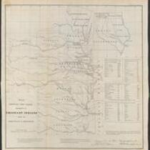
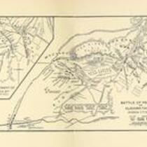
Title
-
Battle of Pea Ridge
-
Description
-
This map of the Battle of Pea Ridge was originally published in Abraham Lincoln: A History, Vol. V, by John G. Nicolay and John Hay.
-
Object Type
-
Map
-
Date
-
n.d.
-
-
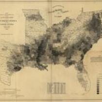
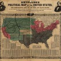
Title
-
Reynolds's Political Map of the United States
-
Description
-
Printed on map: "Designed to exhibit the comparative area of the free and slave states and the territory open to slavery or freedom by the repeal of the Missouri compromise. With a comparison of the principal statistics of the free and slave states, from the census of 1850." Political map delineating the slave states, free states, and open territories, ca. 1856. The maps were created as political propaganda for the first Republican Party candidate for President, John C. Fremont, whose likeness is visible in the upper left corner of the map.
-
Object Type
-
Map
-
-
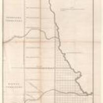
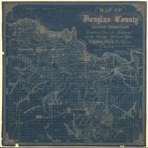
Title
-
Map of Douglas County, Kansas
-
Description
-
This map of Douglas County, Kansas Territory was drawn by I. Cooper Stuck in July of 1857. The map is marked with the locations of individual people's land claims.
-
Object Type
-
Map
-
Date
-
July 1857
-
-
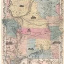
Title
-
Nebraska and Kansas
-
Description
-
This color map, entitled “Nebraska and Kansas,” shows those two territories, the territory acquired from Mexico in 1854, and a small map of the continental United States. The map was published in 1854 by J.H. Colton and Co. in New York.
-
Object Type
-
Map
-
Date
-
1854
-
-
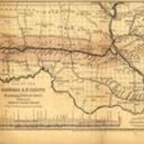
Title
-
Map of the Hannibal & St. Joseph Railroad
-
Description
-
Map of the Hannibal & St. Joseph Railroad, which was chartered in 1847 and completed in 1859. Map depicts northern Missouri and parts of Kansas and Illinois, showing rivers, settlements, railroads, and the land grant awarded to the Hannibal & St. Joseph Railroad.
-
Object Type
-
Map, Image
-
-
Title
-
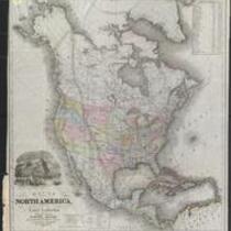
Map of North America Showing Proposed Railroad Routes
-
Description
-
This black-and-white map is entitled “Map of North America, From the Latest Authorities Showing the Proposed Railroad Routes from the Atlantic to the Pacific Oceans.” The map was printed in 1854 by J.H. Colton and Co. in New York, for J. Disturnell.
-
Object Type
-
Map
-
Date
-
1854
-
-
Title
-
Maps of Shawnee Indian Reservation
-
Description
-
These 21 plat maps were made ca. 1857 by Isaac Cooper Stuck. The maps are marked with geographical features and locations of people’s land claims within the Shawnee Indian Reservation in eastern Kansas.
-
Object Type
-
Map
-
-
Title
-
Plan of the Public Surveys in Kansas and Nebraska
-
Description
-
This black-and-white map, signed by J. Calhoun, Surveyor General of Kansas and Nebraska, was issued by the Surveyor General’s office in Wyandott, Kansas Territory on October 20, 1856. The map is entitled "Plan of the Public Surveys in Kansas and Nebraska." It was printed by Ackerman Lithographers in New York.
-
Object Type
-
Map
-
Date
-
October 20, 1856
-

-
Title
-
Sectional Map of Kansas Territory
-
Description
-
This color map, dated April 1857, is entitled "Sectional Map of Kansas Territory." It was drafted by C.P. Wiggin and signed by L.A. MacLean, Chief Clerk of the Surveyor General’s office in Lecompton, Kansas Territory. MacLean certifies that the map was compiled from U.S. survey field notes. The map was published by MacLean and Lawrence and printed by William Schuchman and Bro. in Philadelphia.
-
Object Type
-
Map
-
Date
-
April 1857
-

-
Title
-
Nebraska and Kanzas
-
Description
-
This color map, ca. 1854-1861, is entitled “Nebraska and Kanzas.” It was printed by J.H. Colton and Co. in New York.
-
Object Type
-
Map
-
Date
-
1854-1861
-

-
Title
-
New Sectional Map of Kansas
-
Description
-
This color map, drafted in 1859 by Robert L. Ream, was published by Stevenson and Morris of St. Louis, and printed by A. Janicke and Co. of St. Louis. The map is entitled “New Sectional Map of Kansas,” and was compiled from the field notes in the Surveyor General’s office.
-
Object Type
-
Map
-
Date
-
1859
-

-
Title
-
Sectional Map of the Territory of Kansas
-
Description
-
This color map, entitled “Sectional Map of the Territory of Kansas,” was compiled from the field notes in the Surveyor General’s office. It was published in 1857 by John Halsall in St. Louis.
-
Object Type
-
Map
-
Date
-
1857
-

-
Title
-
Kansas and Nebraska 1856
-
Description
-
This color map, entitled “Kansas and Nebraska 1856,” was printed by J.G. Wells in New York.
-
Object Type
-
Map
-
Date
-
1856
-

-
Title
-
Map Showing the Progress of the Public Surveys in the Territories of Kansas and Nebraska
-
Description
-
This black-and-white map, signed by Ward B. Burnett, Surveyor General, was issued by the Surveyor General’s office in Nebraska City, Nebraska Territory on October 1, 1860. The map shows the progress of the public surveys in the territories of Kansas and Nebraska, and was produced to accompany the Surveyor General’s 1860 annual report.
-
Object Type
-
Map
-
Date
-
October 1, 1860
-

-
Title
-
Map Showing the Progress of the Public Surveys in the Territories of Kansas and Nebraska
-
Description
-
This black-and-white map, signed by Ward B. Burnett, Surveyor General, was issued by the Surveyor General’s office in Nebraska City, Nebraska Territory on October 1, 1859. The map shows the progress of the public surveys in the territories of Kansas and Nebraska, and was produced to accompany the Surveyor General’s 1859 annual report.
-
Object Type
-
Map
-
Date
-
October 1, 1859
-

-
Title
-
Map Showing the Progress of the Public Surveys in Kansas and Nebraska
-
Description
-
This black-and-white map, signed by Mark W. Delahay, Surveyor General, was issued by the Surveyor General’s office in Leavenworth, Kansas on September 2, 1861. The map shows the progress of the public surveys in Kansas and Nebraska, and was produced to accompany the Surveyor General’s report of 1861.
-
Object Type
-
Map
-
Date
-
September 2, 1861
-

-
Title
-
Sketch of the Public Surveys in Kansas and Nebraska
-
Description
-
This black-and-white map, signed by J. Calhoun, Surveyor General, was issued by the Surveyor General’s office in Wyandott, Kansas Territory on November 8, 1856. The map is entitled “Sketch of the Public Surveys in Kansas and Nebraska.” It was printed by A. Hoen and Co. in Baltimore.
-
Object Type
-
Map
-
Date
-
November 8, 1855