Error message
Notice: Trying to access array offset on value of type null in IslandoraSolrDisplayManagerResults->currentQueryDisplays() (line 222 of /var/www/drupal7/sites/all/modules/islandora_solr_display_manager/includes/islandora_solr_display_manager.inc).
-
-
Title
-
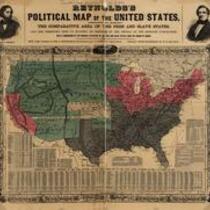
Reynolds's Political Map of the United States
-
Description
-
Printed on map: "Designed to exhibit the comparative area of the free and slave states and the territory open to slavery or freedom by the repeal of the Missouri compromise. With a comparison of the principal statistics of the free and slave states, from the census of 1850." Political map delineating the slave states, free states, and open territories, ca. 1856. The maps were created as political propaganda for the first Republican Party candidate for President, John C. Fremont, whose likeness is visible in the upper left corner of the map.
-
Object Type
-
Map
-
-
Title
-
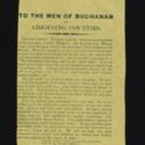
John R. Boyd Handbill
-
Description
-
This handbill, signed by John R. Boyd, urges the citizens of Buchanan County, Missouri to join arms and fight against the “usurping invader, Fremont.” Boyd instructs them to bring their shot guns and rifles to Rock House Prairie, where hundreds of men have set up camp and plan to fight until they achieve freedom, “or be buried beneath the dead bodies of men who would rather die than be slaves.”
-
Object Type
-
Leaflet
-
-
Title
-
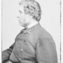
John C. Fremont
-
Description
-
Glass plate negative of military officer, explorer, and politician John C. Fremont in profile, circa 1855-1865.
-
Object Type
-
Image
