
The missouri-kansas conflict 1854-1865
Error message
Notice: Trying to access array offset on value of type null in IslandoraSolrDisplayManagerResults->currentQueryDisplays() (line 222 of /var/www/drupal7/sites/all/modules/islandora_solr_display_manager/includes/islandora_solr_display_manager.inc).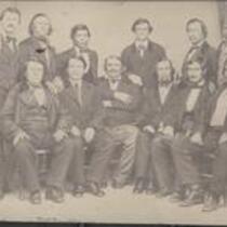


![Constitutional Convention, Topeka, Kansas Territory [Topeka]](https://civilwaronthewesternborder.org/sites/civilwaronthewesternborder.org/files/styles/islandora_imagecache_image_style_medium/public/externals/be261c1645001f328b7032d00e8de879.jpg?itok=o4Mdz8vY&pid=civilwar:1311&iic=true)


Local Subject
- Picturing the War (24)
- Bleeding Kansas, Bloodletting Missouri (15)
- African Americans (3)
- Battle for Missouri, 1861-1865 -- Military History of Missouri and Kansas (3)
- Missouri military units (Confederate) (2)
- Missouri military units (Union) (2)
- Popular Sovereignty (2)
- Battle of Hemp Bales / Battle of Lexington (1)
- Battle of Wilson's Creek (1)
- Bogus Legislature (1)
- Bushwhackers (1)
- Guerrillas (1)
- Kansas military units (1)
- Kansas-Nebraska Act (1)
- Quantrill's Raid on Lawrence (1)
- Surviving a Guerrilla War (1)
- Topeka Constitutional Convention (1)
- Women (1)
People
- J. Calhoun (3)
- Ward B. Burnett (2)
- A. Hoen and Co. (Lithographer) (1)
- A. Janicke and Co. (Lithographer) (1)
- Abraham Lincoln (1)
- Ackerman Lithographers (1)
- Bowen and Co. Lithographers (1)
- C.B. Graham Lithographers (1)
- C.P. Wiggin (1)
- Charles Bluejacket (1)
- Claiborne Fox Jackson (1)
- Col. Dodge (1)
- Hamilton R. Gamble (1)
- Historic American Buildings Survey (1)
- Isaac Cooper Stuck (1)
- J. Bien (Lithographer) (1)
- J.Bien (Lithographer) (1)
- J.G. Wells (Lithographer) (1)
- J.H. Colton and Co. (1)
- J.H. Colton and Co. (Lithographer) (1)
- J.M. Bassett (1)
- Jefferson Davis (1)
- John Halsall (1)
- John Harris (1)
- John K. Hillers (1)
- John Wadsworth (1)
- Joseph Orville Shelby (1)
- Lester Jones (1)
- Lieut. Steen (1)
- MacLean and Lawrence (1)
- Mark W. Delahay (1)
- Robert L. Ream (1)
- Samuel R. Curtis (1)
- Sterling Price (1)
- Stevenson and Morris (1)
- William Clarke Quantrill (1)
- William Schuchman and Bro. (Lithographer) (1)
- William Stinson Soule (1)
Geographic Subject
- Fort Leavenworth, Kansas (14)
- Leavenworth County, Kansas (13)
- Douglas County, Kansas (10)
- Kansas City, Missouri (10)
- Lecompton, Kansas (10)
- Wyandotte County, Kansas (10)
- Atchison County, Kansas (9)
- Atchison, Kansas (9)
- Buchanan County, Missouri (9)
- Doniphan County, Kansas (9)
- Jackson County, Missouri (9)
- Lawrence, Kansas (9)
- Leavenworth, Kansas (9)
- St. Joseph, Missouri (9)
- Topeka, Kansas (9)
- Bourbon County, Kansas (8)
- Fort Scott, Kansas (8)
- Shawnee County, Kansas (8)
- Johnson County, Kansas (6)
- Franklin County, Kansas (4)
- Linn County, Kansas (4)
- Clay County, Missouri (3)
- Jackson County, Kansas (3)
- Quindaro, Kansas (3)
- Weston, Missouri (3)
- Andrew County, Missouri (2)
- Brown County, Kansas (2)
- Fort Riley, Kansas (2)
- Jefferson County, Kansas (2)
- Nodaway County, Missouri (2)
- Platte County, Missouri (2)
- Atchison County, Missouri (1)
- Bates County, Missouri (1)
- Carroll County, Missouri (1)
- Cass County, Missouri (1)
- Chariton County, Missouri (1)
- Clinton County, Missouri (1)
- Dekalb County, Missouri (1)
- Harrison County, Missouri (1)
- Henry County, Missoui (1)
- Holt County, Missouri (1)
- Independence, Missouri (1)
- Johnson County, Missouri (1)
- Liberty, Missouri (1)
- Linn County, Missouri (1)
- Livingston County, Missouri (1)
- Mercer County, Missouri (1)
- Osage County, Kansas (1)
- Ray County, Missouri (1)
- Shawnee Indian Mission, Kansas (1)
Owning Organization
- Lecompton Historical Society (15)
- Internet Archive (2)
- Kansas Historical Society (2)
- Library of Congress Prints and Photographs Division (2)
- National Anthropological Archives, Smithsonian Institution (1)
- Southern Methodist University, Central University Libraries, DeGolyer Library (1)
- St. Joseph Public Library (1)