Error message
Notice: Trying to access array offset on value of type null in IslandoraSolrDisplayManagerResults->currentQueryDisplays() (line 222 of /var/www/drupal7/sites/all/modules/islandora_solr_display_manager/includes/islandora_solr_display_manager.inc).
-
-
Title
-
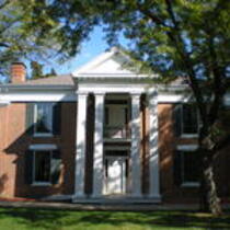
Home of John Wornall
-
Description
-
The home of John Wornall served as a field hospital for soldiers wounded in the Battle of Westport. It has since been restored and converted into a museum, at 6115 Wornall Road in Kansas City, Missouri
-
Object Type
-
Image
-
Date
-
October 2008
-
-
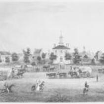
Title
-
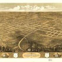
Independence, Missouri
-
Description
-
Bird's eye view of the city of Independence, Jackson Co., Missouri 1868.
-
Object Type
-
Image
-
Date
-
1868
-
-
Title
-
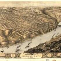
Kansas City, Missouri
-
Description
-
This bird's eye view of Kansas City, Jackson County, Missouri was created by A. Ruger in 1869. A drawing of Kansas City in 1855 is shown in the bottom left corner of the image.
-
Object Type
-
Image
-
Date
-
1869
-
-
Title
-
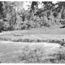
Little Blue River, Jackson County, MO
-
Description
-
This photograph of the Little Blue River was taken in the northwest section of Longview Farm, Longview Road, Lees Summit, Jackson County, MO
-
Object Type
-
Image
-
Date
-
n.d.
-
-
Title
-
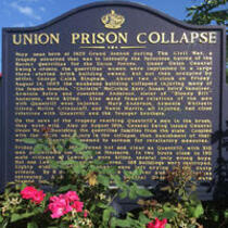
Union Prison Collapse Marker
-
Description
-
Photograph of the historical marker noting the site of the Union Prison collapse in Kansas City, Missouri. The Union Prison, located at 1425 Grand Avenue, held female relatives and associates of proslavery Missouri bushwhackers. Five women, including the sister of guerilla William T. "Bloody Bill" Anderson, died as a result of the collapse on August 14, 1863.
-
Object Type
-
Image
-
Date
-
June 24, 2015
-
-
Title
-
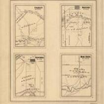
Battlegrounds of Price's Raid
-
Description
-
Maps of the battlefields at "Mine Creek, Oct. 22d 64," "Westport, Oct. 23d 64" "Charlot, Oct. 25th 64," and "Newtonia, Nov. 4th 64," showing the positions of troops, roads, drainage, a few houses, and relief by hachures. Charlot refers to "Charlot's Farm" near Richards, MO. This event is better known as the Battle of the Marmaton River. The Battle of Mine Creek took place south of Pleasanton, KS.
-
Date
-
1865
-
-
Title
-
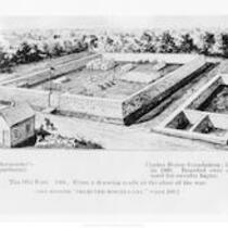
Fort Union
-
Description
-
A drawing made at the close of the war depicting the Quartermaster's Department, Fort Union, and the Coates House Hotel foundation. These structures were located on the southeast corner of 10th and Broadway in Kansas City, Jackson County, Missouri.
-
Object Type
-
Image
-
-
Title
-
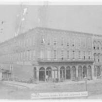
Pacific House Hotel
-
Description
-
Full frontal and side view of the Pacific House Hotel; located on southeast corner of 4th and Delaware. In 1863, it became the District of the Border headquarters, which was then under command of Brigadier General Thomas Ewing Jr..
-
Object Type
-
Image
-
Date
-
1869
-
-
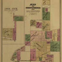
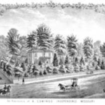
Title
-
The Residence of A. Comingo, Independence, Missouri
-
Description
-
A drawing of A. Comingo's residence in Independnce, Missouri, included in an 1877 plat book of Jackson County, Missouri as originally published by Brink, McDonough & Company.
-
Object Type
-
Image
-
Date
-
1877
-
-
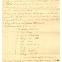
Title
-
List of Stores Expended, 1863
-
Description
-
This military document is a list of items expended by the Head Quarters District of the Border in Kansas City, Missouri while conducting court martials during the last seven months of 1863.
-
Date
-
December 31, 1863
-
-
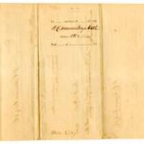
Title
-
Certificate of Lost Horses on October 20th, 1864
-
Description
-
In this military document, Captain James J. Akard certifies that two horses of the Missouri State Militia 8th Cavalry Regiment Company "A" were killed during the Battle of the Big Blue River on October 20, 1864.
-
Date
-
February 16, 1865