Error message
Notice: Trying to access array offset on value of type null in IslandoraSolrDisplayManagerResults->currentQueryDisplays() (line 222 of /var/www/drupal7/sites/all/modules/islandora_solr_display_manager/includes/islandora_solr_display_manager.inc).
-
-
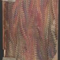
Title
-
Letters Sent (Provost Marshal, Northern District of Kansas)
-
Description
-
This notebook contains copies of correspondence sent by the Provost Marshal's Office, Northern District of Kansas in Leavenworth, Kansas, between August and December 1865. The correspondence addresses topics such as enrollment, desertions, and recruitment efforts. Participants in the correspondence include Quarter Master General M.C. Miegs; Assistant Secretary of War C.A. Dana; and Capt. J. McCahon, Provost Marshal for the Northern District of Kansas.
-
Date
-
August 1865-December 1865
-
-
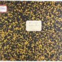
Title
-
Medical Record of Examination of Recruits
-
Description
-
This is a bound volume of records noting the medical examinations of men recruited to the Union Army in Kansas. The records, dating from November 5, 1864 to April 20, 1865, include the recruits' names, ages, country or state of birth, occupation, height, complexion, eye and hair color, chest measurements, race, and town or county of residence.
-
Date
-
November 5, 1864-April 20, 1865
-
-
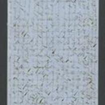
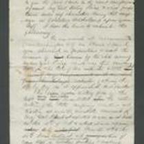
Title
-
From James Griffing to Unknown
-
Description
-
This letter, dated January 10, 1854 but presumably written January 10, 1855, was sent by James Griffing in Wyandotte County, Kansas to an unknown recipient. James discusses pioneer life in Kansas Territory, claiming that it is not at all dangerous: “Our society is mostly all from the East, and you feel just as much composed as when in New England.” Although James believes Missourians are more dangerous than the American Indians, he insists “there is no more reason for a person who attends to his own business to be afraid here” than anywhere else.
-
Date
-
January 10, 1855
-
-
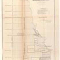
Title
-
Plan of the Public Surveys in Kansas and Nebraska
-
Description
-
This black-and-white map, signed by J. Calhoun, Surveyor General of Kansas and Nebraska, was issued by the Surveyor General’s office in Wyandott, Kansas Territory on October 20, 1856. The map is entitled "Plan of the Public Surveys in Kansas and Nebraska." It was printed by Ackerman Lithographers in New York.
-
Object Type
-
Map
-
Date
-
October 20, 1856
-

-
Title
-
Map Showing the Progress of the Public Surveys in the Territories of Kansas and Nebraska
-
Description
-
This black-and-white map, signed by Ward B. Burnett, Surveyor General, was issued by the Surveyor General’s office in Nebraska City, Nebraska Territory on October 1, 1859. The map shows the progress of the public surveys in the territories of Kansas and Nebraska, and was produced to accompany the Surveyor General’s 1859 annual report.
-
Object Type
-
Map
-
Date
-
October 1, 1859
-

-
Title
-
Map Showing the Progress of the Public Surveys in Kansas and Nebraska
-
Description
-
This black-and-white map, signed by Mark W. Delahay, Surveyor General, was issued by the Surveyor General’s office in Leavenworth, Kansas on September 2, 1861. The map shows the progress of the public surveys in Kansas and Nebraska, and was produced to accompany the Surveyor General’s report of 1861.
-
Object Type
-
Map
-
Date
-
September 2, 1861
-

-
Title
-
Sketch of the Public Surveys in Kansas and Nebraska
-
Description
-
This black-and-white map, signed by J. Calhoun, Surveyor General, was issued by the Surveyor General’s office in Wyandott, Kansas Territory on November 8, 1856. The map is entitled “Sketch of the Public Surveys in Kansas and Nebraska.” It was printed by A. Hoen and Co. in Baltimore.
-
Object Type
-
Map
-
Date
-
November 8, 1855
-
-
Title
-
Report on Price's Raid
-
Description
-
James Henry Lane wrote this report ca. October 1864 about his role in the campaign against Price's Raid. Lane states that he accompanied Gen. Blunt, Col. Moonlight, Col. Jennison, and Gen. Curtis on an expedition into Missouri to impede Sterling Price and his forces. Lane describes the Second Battle of Lexington, the Second Battle of Independence, the Battle of Byram's Ford, the Battle of Westport, and the Battle of Little Blue River.
-

-
Title
-
Map Showing the Progress of the Public Surveys in the Territories of Kansas and Nebraska
-
Description
-
This black-and-white map, signed by J. Calhoun, Surveyor General, was issued by the Surveyor General’s office in Lecompton, Kansas Territory in October 1857. The map shows the progress of the public surveys in the territories of Kansas and Nebraska, and was produced to accompany the Surveyor General’s 1857 annual report.
-
Date
-
October 1857