Error message
Notice: Trying to access array offset on value of type null in IslandoraSolrDisplayManagerResults->currentQueryDisplays() (line 222 of /var/www/drupal7/sites/all/modules/islandora_solr_display_manager/includes/islandora_solr_display_manager.inc).
-
-
Title
-
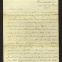
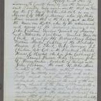
From Sara Robinson to "My Dear Martha"
-
Description
-
This letter, dated October 19, 1862, is from Sara Robinson in Topeka, Kansas to Martha. Sara reports that her husband, Kansas Gov. Charles Robinson, went to Altoona, Pennsylvania to meet "the Governors," but by the time he arrived they had already gone to Washington, D.C. Charles "had no wish to see the Sec. of War or the President, both of whom have treated him & the young state of Kansas so villainously & did not follow them." Sara states that when Charles returned, he went to St. Louis to see Gen. Curtis.
-
Object Type
-
Letter
-
Date
-
October 19, 1862
-
-
Title
-
From James Griffing to Unknown
-
Description
-
This letter, dated January 10, 1854 but presumably written January 10, 1855, was sent by James Griffing in Wyandotte County, Kansas to an unknown recipient. James discusses pioneer life in Kansas Territory, claiming that it is not at all dangerous: “Our society is mostly all from the East, and you feel just as much composed as when in New England.” Although James believes Missourians are more dangerous than the American Indians, he insists “there is no more reason for a person who attends to his own business to be afraid here” than anywhere else.
-
Date
-
January 10, 1855
-
-
Title
-
From Edward Fitch to Dear Parents
-
Description
-
Edward Fitch of Lawrence, Kansas, writes a letter to his parents in Massachusetts on August 9, 1857, announcing that Kansas has voted to ratify the Topeka Constitution. He adds that Free State supporters appear to comprise a majority in Kansas. Fitch complains about a recent Herald of Freedom article on the apportionment of the Kansas Legislature, and claims that it is “the most damning piece of villany ever perpetrated by any men or set of men.”
-
Date
-
August 9, 1857
-
-
Title
-
From Samuel Lyle Adair to Florella Brown Adair
-
Description
-
This letter was written March 26 and 29, and April 1, 1861 by Samuel Lyle Adair in Osawatomie, Kansas, to his wife Florella Brown Adair. Samuel writes that he was forced to borrow money to continue work on the church’s construction, and will likely need to borrow more; he explains that this is difficult in Osawatomie because money is scarce. He states that many people in Kansas are destitute, although aid continues to arrive in the county, including a shipment of seed wheat from the New England Relief Committee.
-
Date
-
March 26, 1861-April 1, 1861
-
-
Title
-
Affidavit of Henry E. McKee
-
Description
-
This is the sworn affidavit of Henry E. McKee, signed by Kansas Gov. John W. Geary on October 4, 1856. McKee claims that on October 2, he witnessed H. Miles Moore enter the American Hotel in Kansas City, Missouri, where eight men captured him. They took Moore to Wyandotte, Kansas and “unlawfully imprisoned” him there, McKee says. He adds that if Moore does not receive help soon, “his life is in great hazard and will be sacrificed.”
-
Object Type
-
Legal Document
-
Date
-
October 4, 1856
-
-
Title
-
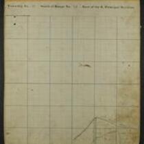
Maps of Shawnee Indian Reservation
-
Description
-
These 21 plat maps were made ca. 1857 by Isaac Cooper Stuck. The maps are marked with geographical features and locations of people’s land claims within the Shawnee Indian Reservation in eastern Kansas.
-
Object Type
-
Map
-
-
Title
-
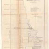
Plan of the Public Surveys in Kansas and Nebraska
-
Description
-
This black-and-white map, signed by J. Calhoun, Surveyor General of Kansas and Nebraska, was issued by the Surveyor General’s office in Wyandott, Kansas Territory on October 20, 1856. The map is entitled "Plan of the Public Surveys in Kansas and Nebraska." It was printed by Ackerman Lithographers in New York.
-
Object Type
-
Map
-
Date
-
October 20, 1856
-

-
Title
-
Map Showing the Progress of the Public Surveys in the Territories of Kansas and Nebraska
-
Description
-
This black-and-white map, signed by Ward B. Burnett, Surveyor General, was issued by the Surveyor General’s office in Nebraska City, Nebraska Territory on October 1, 1860. The map shows the progress of the public surveys in the territories of Kansas and Nebraska, and was produced to accompany the Surveyor General’s 1860 annual report.
-
Object Type
-
Map
-
Date
-
October 1, 1860
-

-
Title
-
Map Showing the Progress of the Public Surveys in the Territories of Kansas and Nebraska
-
Description
-
This black-and-white map, signed by Ward B. Burnett, Surveyor General, was issued by the Surveyor General’s office in Nebraska City, Nebraska Territory on October 1, 1859. The map shows the progress of the public surveys in the territories of Kansas and Nebraska, and was produced to accompany the Surveyor General’s 1859 annual report.
-
Object Type
-
Map
-
Date
-
October 1, 1859
-

-
Title
-
Sketch of the Public Surveys in Kansas and Nebraska
-
Description
-
This black-and-white map, signed by J. Calhoun, Surveyor General, was issued by the Surveyor General’s office in Wyandott, Kansas Territory on November 8, 1856. The map is entitled “Sketch of the Public Surveys in Kansas and Nebraska.” It was printed by A. Hoen and Co. in Baltimore.
-
Object Type
-
Map
-
Date
-
November 8, 1855
-

-
Title
-
Map Showing the Progress of the Public Surveys in the Territories of Kansas and Nebraska
-
Description
-
This black-and-white map, signed by J. Calhoun, Surveyor General, was issued by the Surveyor General’s office in Lecompton, Kansas Territory in October 1857. The map shows the progress of the public surveys in the territories of Kansas and Nebraska, and was produced to accompany the Surveyor General’s 1857 annual report.
-
Date
-
October 1857