Error message
Notice: Trying to access array offset on value of type null in IslandoraSolrDisplayManagerResults->currentQueryDisplays() (line 222 of /var/www/drupal7/sites/all/modules/islandora_solr_display_manager/includes/islandora_solr_display_manager.inc).
-
-
Title
-
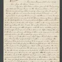
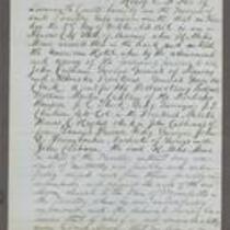
From James Griffing to Unknown
-
Description
-
This letter, dated January 10, 1854 but presumably written January 10, 1855, was sent by James Griffing in Wyandotte County, Kansas to an unknown recipient. James discusses pioneer life in Kansas Territory, claiming that it is not at all dangerous: “Our society is mostly all from the East, and you feel just as much composed as when in New England.” Although James believes Missourians are more dangerous than the American Indians, he insists “there is no more reason for a person who attends to his own business to be afraid here” than anywhere else.
-
Date
-
January 10, 1855
-
-
Title
-
From Abelard Guthrie to James Henry Lane
-
Description
-
This letter, dated November 21, 1864, is from Abelard Guthrie in Quindaro, Kansas to James Henry Lane. Guthrie reports on the proceedings of a Supreme Court case to determine if Kansas has the right to tax land assigned to the Shawnee Indians. Guthrie argues that if the court exempts these areas from taxation, it will deprive "the counties of Douglass, Johnson, and Wyandot of about sixty thousand dollars of taxes which they sorely need."
-
Date
-
November 21, 1864
-
-
Title
-
Affidavit of Henry E. McKee
-
Description
-
This is the sworn affidavit of Henry E. McKee, signed by Kansas Gov. John W. Geary on October 4, 1856. McKee claims that on October 2, he witnessed H. Miles Moore enter the American Hotel in Kansas City, Missouri, where eight men captured him. They took Moore to Wyandotte, Kansas and “unlawfully imprisoned” him there, McKee says. He adds that if Moore does not receive help soon, “his life is in great hazard and will be sacrificed.”
-
Object Type
-
Legal Document
-
Date
-
October 4, 1856
-
-
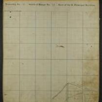
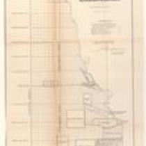
Title
-
Maps of Shawnee Indian Reservation
-
Description
-
These 21 plat maps were made ca. 1857 by Isaac Cooper Stuck. The maps are marked with geographical features and locations of people’s land claims within the Shawnee Indian Reservation in eastern Kansas.
-
Object Type
-
Map
-
-
Title
-
Plan of the Public Surveys in Kansas and Nebraska
-
Description
-
This black-and-white map, signed by J. Calhoun, Surveyor General of Kansas and Nebraska, was issued by the Surveyor General’s office in Wyandott, Kansas Territory on October 20, 1856. The map is entitled "Plan of the Public Surveys in Kansas and Nebraska." It was printed by Ackerman Lithographers in New York.
-
Object Type
-
Map
-
Date
-
October 20, 1856
-

-
Title
-
New Sectional Map of Kansas
-
Description
-
This color map, drafted in 1859 by Robert L. Ream, was published by Stevenson and Morris of St. Louis, and printed by A. Janicke and Co. of St. Louis. The map is entitled “New Sectional Map of Kansas,” and was compiled from the field notes in the Surveyor General’s office.
-
Object Type
-
Map
-
Date
-
1859
-

-
Title
-
Map Showing the Progress of the Public Surveys in the Territories of Kansas and Nebraska
-
Description
-
This black-and-white map, signed by Ward B. Burnett, Surveyor General, was issued by the Surveyor General’s office in Nebraska City, Nebraska Territory on October 1, 1860. The map shows the progress of the public surveys in the territories of Kansas and Nebraska, and was produced to accompany the Surveyor General’s 1860 annual report.
-
Object Type
-
Map
-
Date
-
October 1, 1860
-

-
Title
-
Map Showing the Progress of the Public Surveys in the Territories of Kansas and Nebraska
-
Description
-
This black-and-white map, signed by Ward B. Burnett, Surveyor General, was issued by the Surveyor General’s office in Nebraska City, Nebraska Territory on October 1, 1859. The map shows the progress of the public surveys in the territories of Kansas and Nebraska, and was produced to accompany the Surveyor General’s 1859 annual report.
-
Object Type
-
Map
-
Date
-
October 1, 1859
-

-
Title
-
Map Showing the Progress of the Public Surveys in Kansas and Nebraska
-
Description
-
This black-and-white map, signed by Mark W. Delahay, Surveyor General, was issued by the Surveyor General’s office in Leavenworth, Kansas on September 2, 1861. The map shows the progress of the public surveys in Kansas and Nebraska, and was produced to accompany the Surveyor General’s report of 1861.
-
Object Type
-
Map
-
Date
-
September 2, 1861
-

-
Title
-
Sketch of the Public Surveys in Kansas and Nebraska
-
Description
-
This black-and-white map, signed by J. Calhoun, Surveyor General, was issued by the Surveyor General’s office in Wyandott, Kansas Territory on November 8, 1856. The map is entitled “Sketch of the Public Surveys in Kansas and Nebraska.” It was printed by A. Hoen and Co. in Baltimore.
-
Object Type
-
Map
-
Date
-
November 8, 1855
-

-
Title
-
Map Showing the Progress of the Public Surveys in the Territories of Kansas and Nebraska
-
Description
-
This black-and-white map, signed by J. Calhoun, Surveyor General, was issued by the Surveyor General’s office in Lecompton, Kansas Territory in October 1857. The map shows the progress of the public surveys in the territories of Kansas and Nebraska, and was produced to accompany the Surveyor General’s 1857 annual report.
-
Date
-
October 1857