Error message
Notice: Trying to access array offset on value of type null in IslandoraSolrDisplayManagerResults->currentQueryDisplays() (line 222 of /var/www/drupal7/sites/all/modules/islandora_solr_display_manager/includes/islandora_solr_display_manager.inc).
-
-
Title
-
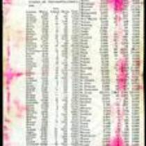
1860 Missouri Census Table
-
Description
-
This ca. 1860 printed document presents the results of the 1860 Missouri census, showing the population of whites, “free colored” and slaves in each county. The table lists the total state population as 1,182,012, with 1,063,599 whites, 3,572 Free Colored, and 114,931 slaves. Lafayette County has the largest slave population with 6,374 slaves. The table also reveals a small American Indian population in Gasconade and Jackson Counties.
-
Object Type
-
Government Document
-
-
Title
-
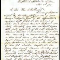
From James Mooney to Robert M. Stewart
-
Description
-
This letter was written on January 4, 1859 by Capt. James Mooney in West Point, Missouri to Missouri Gov. Robert M. Stewart. Mooney describes several recent incidents of robbery, property destruction, and murder perpetrated against the citizens of Bates and Vernon Counties in Missouri by guerrillas from Kansas. Mooney states that a company of 100 men has been organized within the counties; he requests that the company be “properly armed and equipped” and accepted into the service of the state. The final page of the letter is an endorsement of Mooney’s statements by J.A. Pigg and four other men.
-
Date
-
January 4, 1859
-

-
Title
-
Kansas and Nebraska 1856
-
Description
-
This color map, entitled “Kansas and Nebraska 1856,” was printed by J.G. Wells in New York.
-
Object Type
-
Map
-
Date
-
1856
