Error message
Notice: Trying to access array offset on value of type null in IslandoraSolrDisplayManagerResults->currentQueryDisplays() (line 222 of /var/www/drupal7/sites/all/modules/islandora_solr_display_manager/includes/islandora_solr_display_manager.inc).
-
-
Title
-
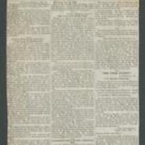
The Western Dispatch.
-
Description
-
This is the August 17, 1856 evening issue of the Western Dispatch, printed in Independence, Missouri. The newspaper announces that war is "being waged by the Abolitionists," and reports that James Henry Lane, John Brown, and their forces have robbed several Kansas residents and driven them into Missouri. The paper also mentions that Kansas Gov. Wilson Shannon requested aid from the U.S. military, but was refused. A last minute extra, printed at the bottom of the paper, states that Lane and his men have captured Lecompton.
-
Object Type
-
Newspaper Article
-
Date
-
August 17, 1856
-
-
Title
-
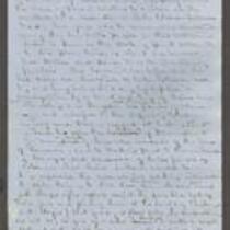
Statement of Wilson Shannon
-
Description
-
This statement by Kansas Gov. Wilson Shannon was written ca. December 1855. Shannon describes the series of events leading to the Wakarusa War, beginning with the murder of a Free State supporter named Charles Dow by Franklin Coleman, a proslavery man. To address the subsequent civil unrest in Douglas County, Kansas, Shannon asks General Richardson, General Strickler, and Col. Sumner to supply troops and assist Douglas County Sheriff Samuel J. Jones in restoring order.
-
Object Type
-
Government Document
-

-
Title
-
Nebraska and Kanzas
-
Description
-
This color map, ca. 1854-1861, is entitled “Nebraska and Kanzas.” It was printed by J.H. Colton and Co. in New York.
-
Object Type
-
Map
-
Date
-
1854-1861
-

-
Title
-
New Sectional Map of Kansas
-
Description
-
This color map, drafted in 1859 by Robert L. Ream, was published by Stevenson and Morris of St. Louis, and printed by A. Janicke and Co. of St. Louis. The map is entitled “New Sectional Map of Kansas,” and was compiled from the field notes in the Surveyor General’s office.
-
Object Type
-
Map
-
Date
-
1859
-

-
Title
-
Map Showing the Progress of the Public Surveys in the Territories of Kansas and Nebraska
-
Description
-
This black-and-white map, signed by Ward B. Burnett, Surveyor General, was issued by the Surveyor General’s office in Nebraska City, Nebraska Territory on October 1, 1860. The map shows the progress of the public surveys in the territories of Kansas and Nebraska, and was produced to accompany the Surveyor General’s 1860 annual report.
-
Object Type
-
Map
-
Date
-
October 1, 1860
-

-
Title
-
Map Showing the Progress of the Public Surveys in the Territories of Kansas and Nebraska
-
Description
-
This black-and-white map, signed by Ward B. Burnett, Surveyor General, was issued by the Surveyor General’s office in Nebraska City, Nebraska Territory on October 1, 1859. The map shows the progress of the public surveys in the territories of Kansas and Nebraska, and was produced to accompany the Surveyor General’s 1859 annual report.
-
Object Type
-
Map
-
Date
-
October 1, 1859
-

-
Title
-
Map Showing the Progress of the Public Surveys in the Territories of Kansas and Nebraska
-
Description
-
This black-and-white map, signed by J. Calhoun, Surveyor General, was issued by the Surveyor General’s office in Lecompton, Kansas Territory in October 1857. The map shows the progress of the public surveys in the territories of Kansas and Nebraska, and was produced to accompany the Surveyor General’s 1857 annual report.
-
Date
-
October 1857
