Error message
Notice: Trying to access array offset on value of type null in IslandoraSolrDisplayManagerResults->currentQueryDisplays() (line 222 of /var/www/drupal7/sites/all/modules/islandora_solr_display_manager/includes/islandora_solr_display_manager.inc).
-
-
Title
-
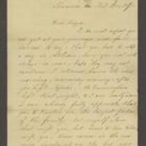
From A.J. Huntoon to Lizzie Huntoon
-
Description
-
A.J. Huntoon writes a letter from Shawnee County, Kansas to his wife Lizzie in New Hampshire. The letter, dated December 30, 1860-January 4, 1861, describes Huntoon’s daily life in Kansas Territory. He also reports to his wife that he plans to travel to Lecompton the following week “to witness the convening of our territorial legislature.”
-
Date
-
December 30, 1860-January 4, 1861
-

-
Title
-
Sectional Map of Kansas Territory
-
Description
-
This color map, dated April 1857, is entitled "Sectional Map of Kansas Territory." It was drafted by C.P. Wiggin and signed by L.A. MacLean, Chief Clerk of the Surveyor General’s office in Lecompton, Kansas Territory. MacLean certifies that the map was compiled from U.S. survey field notes. The map was published by MacLean and Lawrence and printed by William Schuchman and Bro. in Philadelphia.
-
Object Type
-
Map
-
Date
-
April 1857
-

-
Title
-
New Sectional Map of Kansas
-
Description
-
This color map, drafted in 1859 by Robert L. Ream, was published by Stevenson and Morris of St. Louis, and printed by A. Janicke and Co. of St. Louis. The map is entitled “New Sectional Map of Kansas,” and was compiled from the field notes in the Surveyor General’s office.
-
Object Type
-
Map
-
Date
-
1859
-

-
Title
-
Sectional Map of the Territory of Kansas
-
Description
-
This color map, entitled “Sectional Map of the Territory of Kansas,” was compiled from the field notes in the Surveyor General’s office. It was published in 1857 by John Halsall in St. Louis.
-
Object Type
-
Map
-
Date
-
1857
-

-
Title
-
Kansas and Nebraska 1856
-
Description
-
This color map, entitled “Kansas and Nebraska 1856,” was printed by J.G. Wells in New York.
-
Object Type
-
Map
-
Date
-
1856
-

-
Title
-
Map Showing the Progress of the Public Surveys in the Territories of Kansas and Nebraska
-
Description
-
This black-and-white map, signed by Ward B. Burnett, Surveyor General, was issued by the Surveyor General’s office in Nebraska City, Nebraska Territory on October 1, 1860. The map shows the progress of the public surveys in the territories of Kansas and Nebraska, and was produced to accompany the Surveyor General’s 1860 annual report.
-
Object Type
-
Map
-
Date
-
October 1, 1860
-

-
Title
-
Map Showing the Progress of the Public Surveys in the Territories of Kansas and Nebraska
-
Description
-
This black-and-white map, signed by Ward B. Burnett, Surveyor General, was issued by the Surveyor General’s office in Nebraska City, Nebraska Territory on October 1, 1859. The map shows the progress of the public surveys in the territories of Kansas and Nebraska, and was produced to accompany the Surveyor General’s 1859 annual report.
-
Object Type
-
Map
-
Date
-
October 1, 1859
-

-
Title
-
Map Showing the Progress of the Public Surveys in Kansas and Nebraska
-
Description
-
This black-and-white map, signed by Mark W. Delahay, Surveyor General, was issued by the Surveyor General’s office in Leavenworth, Kansas on September 2, 1861. The map shows the progress of the public surveys in Kansas and Nebraska, and was produced to accompany the Surveyor General’s report of 1861.
-
Object Type
-
Map
-
Date
-
September 2, 1861
