Error message
Notice: Trying to access array offset on value of type null in IslandoraSolrDisplayManagerResults->currentQueryDisplays() (line 222 of /var/www/drupal7/sites/all/modules/islandora_solr_display_manager/includes/islandora_solr_display_manager.inc).
-
-
Title
-
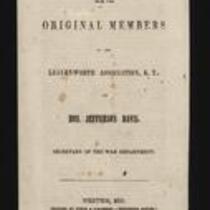
A Letter from the Original Members of the Leavenworth Association, K.T. to Jefferson Davis
-
Description
-
This pamphlet, dated March 13, 1855, is entitled “A Letter from the Original Members of the Leavenworth Association, K.T. to Hon. Jefferson Davis, Secretary of the War Department.” The pamphlet voices the Association’s concerns about Executive Document No. 50 of the 2nd Session of the 33rd Congress, regarding the military Indian reservation at Fort Leavenworth. The pamphlet was printed by Finch & O’Gorman in Weston, Missouri, and is signed by 26 Association members.
-
Object Type
-
Pamphlet
-
Date
-
March 13, 1855
-
-
Title
-
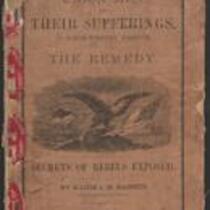
Union Men and Their Sufferings in North-Western Missouri
-
Description
-
This 1864 pamphlet, entitled “Union Men and Their Sufferings in North-Western Missouri,” was written by Major J.M. Bassett, former Provost Marshal-General of the Northwest District of Missouri. Bassett provides a “glance at the history of the Rebellion in Northwest Missouri,” admitting “it may be that my hatred for rebels is too intense, my sympathy for loyal men too strong, to make every sentence I write acceptable to all.” The pamphlet, which features several black-and-white illustrations, was published by the Press of Wynkcop, Hallenbeck, and Thomas in New York, with proceeds from its sale given to The Ladies’ Aid Society of St. Joseph, Missouri.
-
Date
-
1864
-
-
Title
-
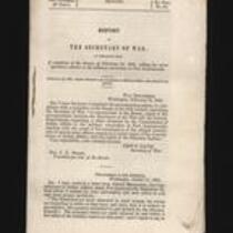
Report of the Secretary of War
-
Description
-
This is Executive Document No. 50, 2nd Session, 33rd Congress, presented to the Senate on February 14, 1855 by Secretary of War Jefferson Davis. The report contains copies of correspondence “respecting a claim advanced by the Commissioner of Indian Affairs to the military reservation at Fort Leavenworth; together with the result of his investigation of the alleged interference of certain army officers…with the rights of the Delaware Indians.”
-
Object Type
-
Government Document
-
Date
-
February 14, 1855
-
-
Title
-
From George W. Collamore to William P. Dole
-
Description
-
This letter, dated April 21, 1862, is from George W. Collamore to Hon. William P. Dole, Commissioner of Indian Affairs. Writing from Washington, DC, Collamore provides an account of his "recent visit to the Loyal Indians who were obliged to flee from their pursuers (the rebel Indians and Texans) in the dead of Winter and are now encamped on the Neosho River" in southern Kansas. Collamore states that these Indians, numbering about 8,000, have suffered and many have died from exposure and lack of food.
-
Date
-
April 21, 1862
-
-
Title
-
Plan of the Public Surveys in Kansas and Nebraska
-
Description
-
This black-and-white map, signed by J. Calhoun, Surveyor General of Kansas and Nebraska, was issued by the Surveyor General’s office in Wyandott, Kansas Territory on October 20, 1856. The map is entitled "Plan of the Public Surveys in Kansas and Nebraska." It was printed by Ackerman Lithographers in New York.
-
Object Type
-
Map
-
Date
-
October 20, 1856
-
-
Title
-
From Edward Fitch to Dear Parents
-
Description
-
In an April 28, 1861 letter to his parents in Massachusetts, Edward Fitch of Lawrence, Kansas declares, “did you think that you would ever live to see it—a Civil War, the most horrible of all wars.” He informs them that he has joined an artillery company. He adds that the military “is organising in large numbers” in Lawrence, but he expresses his fear that if Missouri secedes from the Union, Kansas will not have enough arms or ammunition for defense. He also expresses concern that the Cherokee and Choctaw tribes will fight for the South.
-
Date
-
April 28, 1861
-

-
Title
-
Sectional Map of Kansas Territory
-
Description
-
This color map, dated April 1857, is entitled "Sectional Map of Kansas Territory." It was drafted by C.P. Wiggin and signed by L.A. MacLean, Chief Clerk of the Surveyor General’s office in Lecompton, Kansas Territory. MacLean certifies that the map was compiled from U.S. survey field notes. The map was published by MacLean and Lawrence and printed by William Schuchman and Bro. in Philadelphia.
-
Object Type
-
Map
-
Date
-
April 1857
-

-
Title
-
Nebraska and Kanzas
-
Description
-
This color map, ca. 1854-1861, is entitled “Nebraska and Kanzas.” It was printed by J.H. Colton and Co. in New York.
-
Object Type
-
Map
-
Date
-
1854-1861
-

-
Title
-
New Sectional Map of Kansas
-
Description
-
This color map, drafted in 1859 by Robert L. Ream, was published by Stevenson and Morris of St. Louis, and printed by A. Janicke and Co. of St. Louis. The map is entitled “New Sectional Map of Kansas,” and was compiled from the field notes in the Surveyor General’s office.
-
Object Type
-
Map
-
Date
-
1859
-
-
Title
-
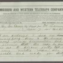
From Samuel R. Curtis to Thomas Carney
-
Description
-
This telegram, dated June 7, 1864, was sent by Maj. Gen. Samuel R. Curtis at Fort Leavenworth, Kansas, to Kansas Gov. Thomas Carney. Curtis states that he has been authorized to issue 1,000 arms and 200,000 rounds of ammunition to the militia. He tells Curtis that “Bushwhackers are east & south of us and hostile thieving indians west but with great vigilance on the part of federal & state troops we may protect the settlement.”
-
Object Type
-
Telegram
-
Date
-
June 7, 1864
-

-
Title
-
Sectional Map of the Territory of Kansas
-
Description
-
This color map, entitled “Sectional Map of the Territory of Kansas,” was compiled from the field notes in the Surveyor General’s office. It was published in 1857 by John Halsall in St. Louis.
-
Object Type
-
Map
-
Date
-
1857
-
-
Title
-
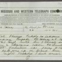
From Unknown to Thomas Carney
-
Description
-
This telegram was sent from Fort Leavenworth, Kansas to Kansas Gov. Thomas Carney on April 26, 1864. The telegram consists of an April 23, 1864 telegraph communication between Col. Phillips and Major General S.R. Curtis. Phillips informs Curtis that his troops are tracking Quantrill’s movements through Kansas along the Arkansas River, and that one of his companies stationed near the river may meet Quantrill soon. Curtis replies that from Phillips’ telegram, he infers Quantrill’s location to be on the southern side of the Arkansas.
-
Object Type
-
Telegram
-
Date
-
April 26, 1864
-

-
Title
-
Kansas and Nebraska 1856
-
Description
-
This color map, entitled “Kansas and Nebraska 1856,” was printed by J.G. Wells in New York.
-
Object Type
-
Map
-
Date
-
1856
-

-
Title
-
Map Showing the Progress of the Public Surveys in the Territories of Kansas and Nebraska
-
Description
-
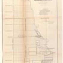
This black-and-white map, signed by Ward B. Burnett, Surveyor General, was issued by the Surveyor General’s office in Nebraska City, Nebraska Territory on October 1, 1860. The map shows the progress of the public surveys in the territories of Kansas and Nebraska, and was produced to accompany the Surveyor General’s 1860 annual report.
-
Object Type
-
Map
-
Date
-
October 1, 1860
-

-
Title
-
Map Showing the Progress of the Public Surveys in the Territories of Kansas and Nebraska
-
Description
-
This black-and-white map, signed by Ward B. Burnett, Surveyor General, was issued by the Surveyor General’s office in Nebraska City, Nebraska Territory on October 1, 1859. The map shows the progress of the public surveys in the territories of Kansas and Nebraska, and was produced to accompany the Surveyor General’s 1859 annual report.
-
Object Type
-
Map
-
Date
-
October 1, 1859
-

-
Title
-
Map Showing the Progress of the Public Surveys in Kansas and Nebraska
-
Description
-
This black-and-white map, signed by Mark W. Delahay, Surveyor General, was issued by the Surveyor General’s office in Leavenworth, Kansas on September 2, 1861. The map shows the progress of the public surveys in Kansas and Nebraska, and was produced to accompany the Surveyor General’s report of 1861.
-
Object Type
-
Map
-
Date
-
September 2, 1861
-

-
Title
-
Sketch of the Public Surveys in Kansas and Nebraska
-
Description
-
This black-and-white map, signed by J. Calhoun, Surveyor General, was issued by the Surveyor General’s office in Wyandott, Kansas Territory on November 8, 1856. The map is entitled “Sketch of the Public Surveys in Kansas and Nebraska.” It was printed by A. Hoen and Co. in Baltimore.
-
Object Type
-
Map
-
Date
-
November 8, 1855
-

-
Title
-
Map Showing the Progress of the Public Surveys in the Territories of Kansas and Nebraska
-
Description
-
This black-and-white map, signed by Ward B. Burnett, Surveyor General, was issued by the Surveyor General’s office in Nebraska City, Nebraska Territory on October 1, 1858. The map depicts the progress of the public surveys in Kansas and Nebraska in 1858, and was created to accompany the Surveyor General's report of that year. The map was printed by C.B. Graham Lithographers in Washington, DC.
-
Date
-
October 1, 1858
-

-
Title
-
Map Showing the Progress of the Public Surveys in the Territories of Kansas and Nebraska
-
Description
-
This black-and-white map, signed by J. Calhoun, Surveyor General, was issued by the Surveyor General’s office in Lecompton, Kansas Territory in October 1857. The map shows the progress of the public surveys in the territories of Kansas and Nebraska, and was produced to accompany the Surveyor General’s 1857 annual report.
-
Date
-
October 1857
-

-
Title
-
Map Depicting the Western Territory
-
Description
-
This undated black-and-white map depicts the Western territory between Fort Leavenworth, Kansas, and the Rocky Mountains. The map shows rivers, Indian territories, villages, and other points of interest. A dotted line indicates the route taken by U.S. dragoons in 1835 under the command of Col. Dodge.
