Notice: Trying to access array offset on value of type null in IslandoraSolrDisplayManagerResults->currentQueryDisplays() (line 222 of /var/www/drupal7/sites/all/modules/islandora_solr_display_manager/includes/islandora_solr_display_manager.inc).
This color map, entitled “Sectional Map of the Territory of Kansas,” was compiled from the field notes in the Surveyor General’s office. It was published in 1857 by John Halsall in St. Louis.
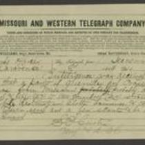
This telegram, dated 1864, is from Major Samuel R. Curtis at Fort Leavenworth to Edmund G. Ross in Lawrence, Kansas. Curtis reports that 150-200 Missouri guerrillas have entered Kansas and are likely to invade Olathe, Lawrence, and Topeka. He tells Ross to warn Topeka of a possible attack and urges him to “be on your guard.”