Error message
Notice: Trying to access array offset on value of type null in IslandoraSolrDisplayManagerResults->currentQueryDisplays() (line 222 of /var/www/drupal7/sites/all/modules/islandora_solr_display_manager/includes/islandora_solr_display_manager.inc).
Pages
-
-
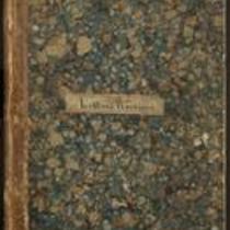
Title
-
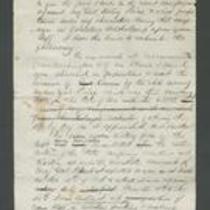
Kansas Colored Volunteers Correspondence
-
Description
-
This bound letterbook contains copies of letters exchanged between the Adjutant General’s Office in Fort Scott, Kansas and various correspondents including the War Department in Washington. The letters relate to the recruitment and commission of troops and officers for the Kansas Colored Volunteers. Participants in the correspondence include Major General James G. Blunt, Major General J.M. Schofield, Secretary of War Edwin Stanton, and Kansas Governor Thomas Carney.
-
Date
-
1863-1864
-
-
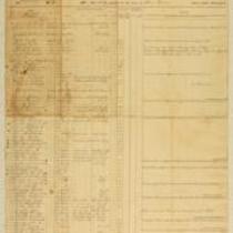
Title
-
Muster Rolls of Kansas Volunteer Regiments
-
Description
-
These muster rolls from 1861 and 1862 list the names, ranks, and enrollment dates of soldiers in companies from the 4th and 10th Kansas Volunteer Regiments. They also list the names of soldiers who deserted their regiments or were discharged, transferred, or deceased. The companies were commanded by Capt. James M. Harvey, Capt. James H. Harris, Col. William Weir, and Col. William Cloud.
-
Date
-
1861-1862
-

-
Title
-
Sectional Map of Kansas Territory
-
Description
-
This color map, dated April 1857, is entitled "Sectional Map of Kansas Territory." It was drafted by C.P. Wiggin and signed by L.A. MacLean, Chief Clerk of the Surveyor General’s office in Lecompton, Kansas Territory. MacLean certifies that the map was compiled from U.S. survey field notes. The map was published by MacLean and Lawrence and printed by William Schuchman and Bro. in Philadelphia.
-
Object Type
-
Map
-
Date
-
April 1857
-
-
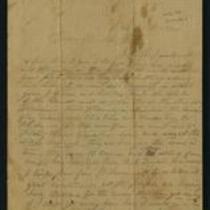
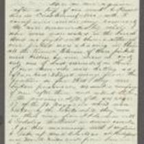
Title
-
From Calvin Iserman to Brother William
-
Description
-
This letter, ca. April 1861, was sent by Calvin Iserman in Independence, Missouri, to his brother William. Calvin writes that Independence “is the strongest secession town” in Missouri. He writes that men from Independence “seized the State Arsenal” at Liberty, and Lincoln has ordered federal troops to retake it. Calvin declares that all Union supporters “who can get away” are leaving the area. The letter includes a brief note addressed to “sister Gusta,” presumably written by Calvin's wife.
-
-
Title
-
From Daniel R. Anthony to Father
-
Description
-
This letter, dated November 24, 1861, was written by Daniel R. Anthony at Camp Union, Kansas City, Missouri, to his father. Anthony describes commanding eight companies on a recent military expedition to Pleasant Hill in Cass County, Missouri; he is now on his way to take up headquarters at Independence, Missouri. Anthony discusses his involvement in a “desperate” battle at the Little Blue River near Independence, in which the Union side won. He also says that a soldier under his command found guilty of stealing will be shot that morning.
-
Date
-
November 24, 1861
-

-
Title
-
Nebraska and Kanzas
-
Description
-
This color map, ca. 1854-1861, is entitled “Nebraska and Kanzas.” It was printed by J.H. Colton and Co. in New York.
-
Object Type
-
Map
-
Date
-
1854-1861
-
-
Title
-
From A.J. Huntoon to Lizzie P. Huntoon
-
Description
-
In this letter, dated July 17 and July 20, 1861, A.J. Huntoon writes to his wife Lizzie P. Huntoon. On July 17, A.J. writes from Camp Lincoln, headquarters of the 3rd Regiment, Kansas Volunteers, in Fort Leavenworth, Kansas. A.J. describes his trip from Topeka to Fort Leavenworth, stating that four companies are in camp there, while another five have gone to Kansas City. On July 20, A.J. reports he is in camp at Kansas City, where there are rumors of an imminent secessionist attack; he believes there is no great danger.
-
Date
-
July 17, 1861-July 20, 1861
-

-
Title
-
New Sectional Map of Kansas
-
Description
-
This color map, drafted in 1859 by Robert L. Ream, was published by Stevenson and Morris of St. Louis, and printed by A. Janicke and Co. of St. Louis. The map is entitled “New Sectional Map of Kansas,” and was compiled from the field notes in the Surveyor General’s office.
-
Object Type
-
Map
-
Date
-
1859
-
-
Title
-
From A.J. Huntoon to My Dear Wife
-
Description
-
A.J. Huntoon writes a letter from Williamsport in Shawnee County, Kansas to his wife Lizzie, reporting that Rebels have fired at U.S. troops in Independence, Missouri. He adds that hundreds of Kansas troops have left Lawrence and Fort Leavenworth to assist U.S. troops in Kansas City and St. Joseph, Missouri. The letter, dated June 16 and 19, 1861, also mentions recent shootings in Leavenworth and Atchison, Kansas. Huntoon writes, “We may look for these as common occurrences in Kansas, for a while at least. All carry arms now . . . Men are paying out their last cent for them.”
-
Date
-
June 16, 1861-June 19, 1861
-

-
Title
-
From A.J. Sexton to Catherine
-
Description
-
A.J. Sexton writes a letter from Leavenworth, Kansas to his wife Catherine in Wisconsin on February 26, 1862. Sexton, a member of the 12th Regiment of Wisconsin Infantry Volunteers, describes daily life at Fort Leavenworth, where his company is headquartered. He also announces that the city of Nashville recently surrendered to the Union and “the general opinion is that the war will soon close.”
-
Date
-
February 26, 1862
-

-
Title
-
Sectional Map of the Territory of Kansas
-
Description
-
This color map, entitled “Sectional Map of the Territory of Kansas,” was compiled from the field notes in the Surveyor General’s office. It was published in 1857 by John Halsall in St. Louis.
-
Object Type
-
Map
-
Date
-
1857
-

-
Title
-
From Samuel R. Ayres to Lyman Langdon
-
Description
-
In this letter, dated November 15, 1861, Samuel R. Ayres tells Lyman Langdon that he recently travelled to Kansas City, Missouri on an expedition to escort a provision train, but the train was captured by Secessionists. Ayres tells Langdon that there are a lot of Secessionists in Clay County, Missouri, and he suspects that they will try to take possession of Kansas City. He also mentions a rumor that Gen. Lane is in danger, as his regiment is vastly outnumbered by the enemy, but he plans to unite his forces with those of Col. Jennison.
-
Date
-
November 15, 1861
-
-
Title
-
From Fred to Dear Cousins
-
Description
-
This February 28, 1862 letter is from a soldier named Fred to his cousins. He reports that he just marched from Fort Leavenworth, Kansas with Company A, to Kansas City, Missouri, where they are guarding Fort Union against the Jayhawkers. He tells his cousins that the 2nd Battalion of his regiment "had a brush with the rebels at Independence," and adds that he may be marching to St. Louis soon.
-
Date
-
February 28, 1862
-
-
Title
-
From W.E. Prince to James Henry Lane
-
Description
-
This dispatch, dated September 23, 1861, is from Capt. W.E. Prince at Fort Leavenworth, Kansas to Gen. James Henry Lane. Prince reports that the Union forces surrendered to the Missouri State Guard at the First Battle of Lexington on September 20. He also states that Gen. Sturgis expects Lane and his troops to report to Kansas City.
-
Date
-
September 23, 1861
-

-
Title
-
Map Showing the Progress of the Public Surveys in the Territories of Kansas and Nebraska
-
Description
-
This black-and-white map, signed by Ward B. Burnett, Surveyor General, was issued by the Surveyor General’s office in Nebraska City, Nebraska Territory on October 1, 1860. The map shows the progress of the public surveys in the territories of Kansas and Nebraska, and was produced to accompany the Surveyor General’s 1860 annual report.
-
Object Type
-
Map
-
Date
-
October 1, 1860
-

-
Title
-
Map Showing the Progress of the Public Surveys in the Territories of Kansas and Nebraska
-
Description
-
This black-and-white map, signed by Ward B. Burnett, Surveyor General, was issued by the Surveyor General’s office in Nebraska City, Nebraska Territory on October 1, 1859. The map shows the progress of the public surveys in the territories of Kansas and Nebraska, and was produced to accompany the Surveyor General’s 1859 annual report.
-
Object Type
-
Map
-
Date
-
October 1, 1859
-

-
Title
-
Map Showing the Progress of the Public Surveys in Kansas and Nebraska
-
Description
-
This black-and-white map, signed by Mark W. Delahay, Surveyor General, was issued by the Surveyor General’s office in Leavenworth, Kansas on September 2, 1861. The map shows the progress of the public surveys in Kansas and Nebraska, and was produced to accompany the Surveyor General’s report of 1861.
-
Object Type
-
Map
-
Date
-
September 2, 1861
-
-
Title
-
Report on Price's Raid
-
Description
-
James Henry Lane wrote this report ca. October 1864 about his role in the campaign against Price's Raid. Lane states that he accompanied Gen. Blunt, Col. Moonlight, Col. Jennison, and Gen. Curtis on an expedition into Missouri to impede Sterling Price and his forces. Lane describes the Second Battle of Lexington, the Second Battle of Independence, the Battle of Byram's Ford, the Battle of Westport, and the Battle of Little Blue River.
-

-
Title
-
Map Showing the Progress of the Public Surveys in the Territories of Kansas and Nebraska
-
Description
-
This black-and-white map, signed by Ward B. Burnett, Surveyor General, was issued by the Surveyor General’s office in Nebraska City, Nebraska Territory on October 1, 1858. The map depicts the progress of the public surveys in Kansas and Nebraska in 1858, and was created to accompany the Surveyor General's report of that year. The map was printed by C.B. Graham Lithographers in Washington, DC.
-
Date
-
October 1, 1858
-

-
Title
-
Map Showing the Progress of the Public Surveys in the Territories of Kansas and Nebraska
-
Description
-
This black-and-white map, signed by J. Calhoun, Surveyor General, was issued by the Surveyor General’s office in Lecompton, Kansas Territory in October 1857. The map shows the progress of the public surveys in the territories of Kansas and Nebraska, and was produced to accompany the Surveyor General’s 1857 annual report.
-
Date
-
October 1857
Pages
