Error message
Notice: Trying to access array offset on value of type null in IslandoraSolrDisplayManagerResults->currentQueryDisplays() (line 222 of /var/www/drupal7/sites/all/modules/islandora_solr_display_manager/includes/islandora_solr_display_manager.inc).
-
-
Title
-
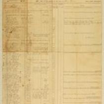
Muster Rolls of Kansas Volunteer Regiments
-
Description
-
These muster rolls from 1861 and 1862 list the names, ranks, and enrollment dates of soldiers in companies from the 4th and 10th Kansas Volunteer Regiments. They also list the names of soldiers who deserted their regiments or were discharged, transferred, or deceased. The companies were commanded by Capt. James M. Harvey, Capt. James H. Harris, Col. William Weir, and Col. William Cloud.
-
Date
-
1861-1862
-

-
Title
-
Sectional Map of Kansas Territory
-
Description
-
This color map, dated April 1857, is entitled "Sectional Map of Kansas Territory." It was drafted by C.P. Wiggin and signed by L.A. MacLean, Chief Clerk of the Surveyor General’s office in Lecompton, Kansas Territory. MacLean certifies that the map was compiled from U.S. survey field notes. The map was published by MacLean and Lawrence and printed by William Schuchman and Bro. in Philadelphia.
-
Object Type
-
Map
-
Date
-
April 1857
-

-
Title
-
New Sectional Map of Kansas
-
Description
-
This color map, drafted in 1859 by Robert L. Ream, was published by Stevenson and Morris of St. Louis, and printed by A. Janicke and Co. of St. Louis. The map is entitled “New Sectional Map of Kansas,” and was compiled from the field notes in the Surveyor General’s office.
-
Object Type
-
Map
-
Date
-
1859
-

-
Title
-
From Charles Adair to Samuel Lyle Adair, Florella Brown Adair, Emma Adair, and Ada Adair
-
Description
-
On December 10 and 13, 1862, Charles Adair writes from Rays Mill and Cane Hill, Arkansas, to his parents Florella Brown Adair and Samuel Lyle Adair, and sisters Emma and Ada Adair. Charles reports that he was involved in a “hard battle” at Boonesboro, Arkansas on November 28, and provides a brief account of the fighting. He also describes the Battle of Prairie Grove, in which his regiment fought on December 7. Charles says that they are given enough clothing and food in the army, but “I have suffered dreadfully for the want of sleep.”
-
Date
-
December 10, 1862-December 13, 1862
-

-
Title
-
From A.J. Sexton to Catherine
-
Description
-
A.J. Sexton writes a letter from Leavenworth, Kansas to his wife Catherine in Wisconsin on February 26, 1862. Sexton, a member of the 12th Regiment of Wisconsin Infantry Volunteers, describes daily life at Fort Leavenworth, where his company is headquartered. He also announces that the city of Nashville recently surrendered to the Union and “the general opinion is that the war will soon close.”
-
Date
-
February 26, 1862
-

-
Title
-
Sectional Map of the Territory of Kansas
-
Description
-
This color map, entitled “Sectional Map of the Territory of Kansas,” was compiled from the field notes in the Surveyor General’s office. It was published in 1857 by John Halsall in St. Louis.
-
Object Type
-
Map
-
Date
-
1857
-
-
Title
-
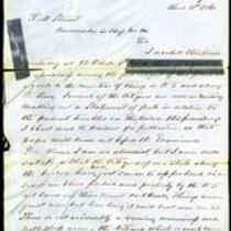
From G.A. Parsons to Robert M. Stewart
-
Description
-
This letter, dated December 2, 1860, is from G.A. Parsons, Adjutant General of the Missouri Militia, to Missouri Gov. Robert M. Stewart. Parsons informs Stewart that he has just arrived in Bates County and has found among its citizens “a good deal of uneasiness” because of recent attacks by Jayhawkers. He mentions that a citizen named Bishop was recently shot in his own house. Parsons states that he is enclosing a petition from Bates County citizens.
-
Date
-
December 2, 1860
-

-
Title
-
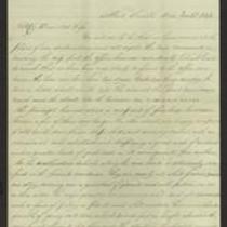
From Samuel R. Ayres to Lyman Langdon
-
Description
-
In this letter, dated November 15, 1861, Samuel R. Ayres tells Lyman Langdon that he recently travelled to Kansas City, Missouri on an expedition to escort a provision train, but the train was captured by Secessionists. Ayres tells Langdon that there are a lot of Secessionists in Clay County, Missouri, and he suspects that they will try to take possession of Kansas City. He also mentions a rumor that Gen. Lane is in danger, as his regiment is vastly outnumbered by the enemy, but he plans to unite his forces with those of Col. Jennison.
-
Date
-
November 15, 1861
-

-
Title
-
Kansas and Nebraska 1856
-
Description
-
This color map, entitled “Kansas and Nebraska 1856,” was printed by J.G. Wells in New York.
-
Object Type
-
Map
-
Date
-
1856
-
-
Title
-
From Joseph H. Trego to Alice Trego
-
Description
-
In this letter, dated November 23, 1863, Lieut. Joseph H. Trego of the 5th Kansas Cavalry Regiment informs his wife Alice that he has safely arrived at Fort Smith, Arkansas. He says that scouts from his regiment captured about a dozen Bushwhackers and that Gen. McNeil “is keeping them here to have them ready to hang to telegraph poles.” Trego also mentions that Gen. Blunt is at Fort Smith and is likely to be reinstated to his command.
-
Date
-
November 23, 1863
-

-
Title
-
Map Showing the Progress of the Public Surveys in the Territories of Kansas and Nebraska
-
Description
-
This black-and-white map, signed by Ward B. Burnett, Surveyor General, was issued by the Surveyor General’s office in Nebraska City, Nebraska Territory on October 1, 1860. The map shows the progress of the public surveys in the territories of Kansas and Nebraska, and was produced to accompany the Surveyor General’s 1860 annual report.
-
Object Type
-
Map
-
Date
-
October 1, 1860
-

-
Title
-
Map Showing the Progress of the Public Surveys in the Territories of Kansas and Nebraska
-
Description
-
This black-and-white map, signed by Ward B. Burnett, Surveyor General, was issued by the Surveyor General’s office in Nebraska City, Nebraska Territory on October 1, 1859. The map shows the progress of the public surveys in the territories of Kansas and Nebraska, and was produced to accompany the Surveyor General’s 1859 annual report.
-
Object Type
-
Map
-
Date
-
October 1, 1859
-
-
Title
-
From Leigh R. Webber to "Senorita Morena"
-
Description
-
This letter, dated April 30, 1862, is from Leigh R. Webber in "Camp of the Kansas First" to "Senorita Morena" (Miss Brown). Webber says his regiment is comfortably situated, and declares, "Fort Riley is not to be slurred at. It beats Fort Leavenworth all hollow, and Fort Scott is nowhere beside it." He reports that "We had a general inspection on Monday, and were mustered this forenoon," and adds that the soldiers will soon receive new equipment and arms.
-
Object Type
-
Letter
-
Date
-
April 30, 1862
-

-
Title
-
Map Showing the Progress of the Public Surveys in the Territories of Kansas and Nebraska
-
Description
-
This black-and-white map, signed by Ward B. Burnett, Surveyor General, was issued by the Surveyor General’s office in Nebraska City, Nebraska Territory on October 1, 1858. The map depicts the progress of the public surveys in Kansas and Nebraska in 1858, and was created to accompany the Surveyor General's report of that year. The map was printed by C.B. Graham Lithographers in Washington, DC.
-
Date
-
October 1, 1858
-

-
Title
-
Map Showing the Progress of the Public Surveys in the Territories of Kansas and Nebraska
-
Description
-
This black-and-white map, signed by J. Calhoun, Surveyor General, was issued by the Surveyor General’s office in Lecompton, Kansas Territory in October 1857. The map shows the progress of the public surveys in the territories of Kansas and Nebraska, and was produced to accompany the Surveyor General’s 1857 annual report.
-
Date
-
October 1857
