Error message
Notice: Trying to access array offset on value of type null in IslandoraSolrDisplayManagerResults->currentQueryDisplays() (line 222 of /var/www/drupal7/sites/all/modules/islandora_solr_display_manager/includes/islandora_solr_display_manager.inc).
Pages
-
-
Title
-
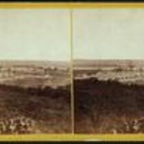
Fort Leavenworth, Kansas
-
Description
-
Stereograph of Fort Leavenworth, Kansas, from 1867. Fort Leavenworth was originally established in 1827 to provide protection along the Santa Fe Trail. During the Civil War, Fort Leavenworth served as a training station for Kansas volunteers, and in 1864 the fort's garrison prepared for a possible attack by Major General Sterling Price on his Missouri Expedition. At an age of more than 180 years, Fort Leavenworth is the oldest post west of Washington, D.C. that remains in continuous operation.
-
Object Type
-
Image
-
Date
-
1867
-
-
Title
-
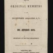
A Letter from the Original Members of the Leavenworth Association, K.T. to Jefferson Davis
-
Description
-
This pamphlet, dated March 13, 1855, is entitled “A Letter from the Original Members of the Leavenworth Association, K.T. to Hon. Jefferson Davis, Secretary of the War Department.” The pamphlet voices the Association’s concerns about Executive Document No. 50 of the 2nd Session of the 33rd Congress, regarding the military Indian reservation at Fort Leavenworth. The pamphlet was printed by Finch & O’Gorman in Weston, Missouri, and is signed by 26 Association members.
-
Object Type
-
Pamphlet
-
Date
-
March 13, 1855
-
-
Title
-
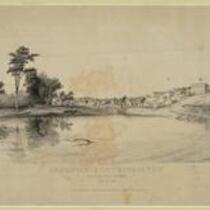
Leavenworth City, Kansas Territory
-
Description
-
Depiction of the city of Leavenworth, Kansas in 1856. Missourians from Weston, Missouri and residents of Fort Leavenworth founded the city in the fall of 1854.
-
Object Type
-
Image
-
Date
-
n.d.
-
-
Title
-
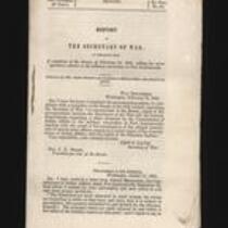
Report of the Secretary of War
-
Description
-
This is Executive Document No. 50, 2nd Session, 33rd Congress, presented to the Senate on February 14, 1855 by Secretary of War Jefferson Davis. The report contains copies of correspondence “respecting a claim advanced by the Commissioner of Indian Affairs to the military reservation at Fort Leavenworth; together with the result of his investigation of the alleged interference of certain army officers…with the rights of the Delaware Indians.”
-
Object Type
-
Government Document
-
Date
-
February 14, 1855
-
-
Title
-
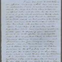
From George W. Collamore to William P. Dole
-
Description
-
This letter, dated April 21, 1862, is from George W. Collamore to Hon. William P. Dole, Commissioner of Indian Affairs. Writing from Washington, DC, Collamore provides an account of his "recent visit to the Loyal Indians who were obliged to flee from their pursuers (the rebel Indians and Texans) in the dead of Winter and are now encamped on the Neosho River" in southern Kansas. Collamore states that these Indians, numbering about 8,000, have suffered and many have died from exposure and lack of food.
-
Date
-
April 21, 1862
-
-
Title
-
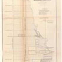
Plan of the Public Surveys in Kansas and Nebraska
-
Description
-
This black-and-white map, signed by J. Calhoun, Surveyor General of Kansas and Nebraska, was issued by the Surveyor General’s office in Wyandott, Kansas Territory on October 20, 1856. The map is entitled "Plan of the Public Surveys in Kansas and Nebraska." It was printed by Ackerman Lithographers in New York.
-
Object Type
-
Map
-
Date
-
October 20, 1856
-
-
Title
-
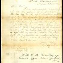
From Wilson Shannon to E.V. Sumner
-
Description
-
This letter, dated June 23, 1856, was sent by Kansas Gov. Wilson Shannon in Lecompton, Kansas, to Col. E.V. Sumner. Shannon, who is leaving for St. Louis, instructs Sumner to station U.S. troops in areas where disturbances have recently occurred, and to station two companies at Topeka before the Free State legislative assembly meets on July 4th. Shannon believes that “if this body meets, enacts laws, and seeks to enforce them…civil war will be the inevitable result.” He orders Sumner to disband the assembly by force if necessary.
-
Date
-
June 23, 1856
-

-
Title
-
From Thomas Swords to John Dougherty
-
Description
-
This letter, dated June 25, 1856, is from Col. Thomas Swords in New York to Maj. John Dougherty. Swords expresses regret that the Kansas-Nebraska Act has resulted in conflict for Kansas Territory. He describes the Kansas-Nebraska Act as "a most just one" that "should have been carried out in the right spirit," and he voices hope that the future will bring peace to Kansas.
-
Date
-
June 25, 1856
-

-
Title
-
Sectional Map of Kansas Territory
-
Description
-
This color map, dated April 1857, is entitled "Sectional Map of Kansas Territory." It was drafted by C.P. Wiggin and signed by L.A. MacLean, Chief Clerk of the Surveyor General’s office in Lecompton, Kansas Territory. MacLean certifies that the map was compiled from U.S. survey field notes. The map was published by MacLean and Lawrence and printed by William Schuchman and Bro. in Philadelphia.
-
Object Type
-
Map
-
Date
-
April 1857
-
-
Title
-
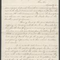
From D.B. Mitchell to Robert M. Stewart
-
Description
-
This letter was written on April 29, 1858 by D.B. Mitchell in Fort Leavenworth, Kansas, to Missouri Gov. Robert M. Stewart in Jefferson City, Missouri. Mitchell says it is likely that two regiments of Missouri volunteers will be called into service, and that one of them will be taken from the state. Mitchell writes, “Should this be the case please bear in mind that you promised the command to me. I can tender you the service of a splendid regiment within ten days after the requisition is made.”
-
Object Type
-
Letter
-
Date
-
April 29, 1858
-

-
Title
-
From Wilson Shannon to E.V. Sumner
-
Description
-
This dispatch, dated June 23, 1856, was sent by Kansas Gov. Wilson Shannon in Lecompton, Kansas, to Col. E.V. Sumner. Shannon, who says he will soon leave for St. Louis, urges Sumner to attend the meeting of the Topeka legislature. Shannon indicates that he fears an outbreak of violence will occur if U.S. troops are withdrawn from Kansas, and says he will write to President Pierce saying so. Shannon requests that Sumner make no changes with the troops until he returns in ten days’ time.
-
Date
-
June 23, 1856
-

-
Title
-
Nebraska and Kanzas
-
Description
-
This color map, ca. 1854-1861, is entitled “Nebraska and Kanzas.” It was printed by J.H. Colton and Co. in New York.
-
Object Type
-
Map
-
Date
-
1854-1861
-

-
Title
-
New Sectional Map of Kansas
-
Description
-
This color map, drafted in 1859 by Robert L. Ream, was published by Stevenson and Morris of St. Louis, and printed by A. Janicke and Co. of St. Louis. The map is entitled “New Sectional Map of Kansas,” and was compiled from the field notes in the Surveyor General’s office.
-
Object Type
-
Map
-
Date
-
1859
-

-
Title
-
Sectional Map of the Territory of Kansas
-
Description
-
This color map, entitled “Sectional Map of the Territory of Kansas,” was compiled from the field notes in the Surveyor General’s office. It was published in 1857 by John Halsall in St. Louis.
-
Object Type
-
Map
-
Date
-
1857
-

-
Title
-
Kansas and Nebraska 1856
-
Description
-
This color map, entitled “Kansas and Nebraska 1856,” was printed by J.G. Wells in New York.
-
Object Type
-
Map
-
Date
-
1856
-

-
Title
-
Map Showing the Progress of the Public Surveys in the Territories of Kansas and Nebraska
-
Description
-
This black-and-white map, signed by Ward B. Burnett, Surveyor General, was issued by the Surveyor General’s office in Nebraska City, Nebraska Territory on October 1, 1860. The map shows the progress of the public surveys in the territories of Kansas and Nebraska, and was produced to accompany the Surveyor General’s 1860 annual report.
-
Object Type
-
Map
-
Date
-
October 1, 1860
-

-
Title
-
Map Showing the Progress of the Public Surveys in the Territories of Kansas and Nebraska
-
Description
-
This black-and-white map, signed by Ward B. Burnett, Surveyor General, was issued by the Surveyor General’s office in Nebraska City, Nebraska Territory on October 1, 1859. The map shows the progress of the public surveys in the territories of Kansas and Nebraska, and was produced to accompany the Surveyor General’s 1859 annual report.
-
Object Type
-
Map
-
Date
-
October 1, 1859
-

-
Title
-
From Wilson Shannon to E.V. Sumner
-
Description
-
This dispatch, dated April 20, 1856, was sent by Kansas Gov. Wilson Shannon in Lecompton, Kansas, to Col. E.V. Sumner. Shannon states that after Douglas County Sheriff Samuel J. Jones arrested a man named S.N. Wood, he was forcibly rescued by a band of men. In order to recapture Wood and make several additional arrests, Shannon instructs Sumner to send an officer and six U.S. troops to Lecompton to assist Jones. Shannon indicates that he prefers to employ U.S. troops for this purpose because of their political neutrality.
-
Date
-
April 20, 1856
-

-
Title
-
Sketch of the Public Surveys in Kansas and Nebraska
-
Description
-
This black-and-white map, signed by J. Calhoun, Surveyor General, was issued by the Surveyor General’s office in Wyandott, Kansas Territory on November 8, 1856. The map is entitled “Sketch of the Public Surveys in Kansas and Nebraska.” It was printed by A. Hoen and Co. in Baltimore.
-
Object Type
-
Map
-
Date
-
November 8, 1855
-
-
Title
-
From Edward Hoogland and John A.W. Jones to John W. Geary
-
Description
-
In this November 29, 1856 letter, Edward Hoogland and John A.W. Jones report to Kansas Gov. John W. Geary about their recent expedition to southeastern Kansas. They inform Geary that they took depositions, issued warrants, and made arrests in relation to a number of crimes, including some committed during the Pottawatomie Massacre. They also report that they found and returned a substantial amount of stolen property. Hoogland and Jones ask Geary to station U.S. troops in southeastern Kansas, suggesting that “their presence would aid in restoring confidence.”
-
Date
-
November 29, 1856
Pages
