Error message
Notice: Trying to access array offset on value of type null in IslandoraSolrDisplayManagerResults->currentQueryDisplays() (line 222 of /var/www/drupal7/sites/all/modules/islandora_solr_display_manager/includes/islandora_solr_display_manager.inc).
-
-
Title
-
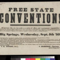
Free State Convention!
-
Description
-
Invitation to the Free State Convention in Big Springs, Kansas. On September 5-6, 1855, approximately 100 delegates gathered at Big Springs, Kansas, along the California Road in Douglas County, to form the Free-State Party. The party supported the entry of Kansas into the Union as a free state, but it did not necessarily espouse abolition of slavery in the South, a position commonly considered to be radical in both the North and the South.
-
Object Type
-
Image
-
Date
-
1855
-
-
Title
-
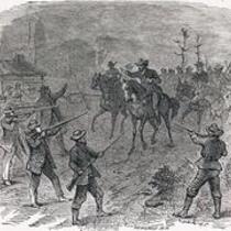
Rescue of Jacob Branson, 1855
-
Description
-
Woodcut depicting the rescue of Free-Stater Jacob Branson following his arrest for threats made to Franklin Coleman. A skirmish broke out in the Wakarusa River Valley near Lawrence, Kansas, following the murder of Charles Dow, a Free-State settler who was killed by the proslavery Franklin Coleman. While the murder was not about politics, the resulting political unrest led Douglas County Sheriff Samuel J. Jones to raise a militia and place Lawrence under siege. The "war" claimed one more victim, a Free-Stater named Thomas Barber.
-
Object Type
-
Image
-
Date
-
1855
-
-
Title
-
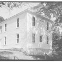
Constitution Hall, Lecompton, Kansas
-
Description
-
Photograph of Constitution Hall, site of the Lecompton Constitutional Convention on January 12, 1857. Constitution Hall was built in 1856 and restored in 1991.
-
Object Type
-
Image
-
Date
-
1933
-

-
Title
-
Camp Saunders, Kansas Territory
-
Description
-
Photograph of proslavery stronghold, Camp Saunders, located 12 miles southwest of Lawrence, Kansas Territory, 1856. Camp (Fort) Saunders, one of three proslavery "forts" in Douglas County, Kansas, came under attack from Free-Staters, led by James H. Lane and angered at the Sacking of Lawrence and the murder of Major S. D. Hoyt, who had traveled to Fort Saunders to request an end to hostilities. The proslavery men at Fort Saunders (which was really no more than a sturdy log cabin), surrendered before any fighting began. The building was burned to the ground, and the Free-Staters turned their attention to Fort Titus.
-
Object Type
-
Image
-
Date
-
1856
-
-
Title
-
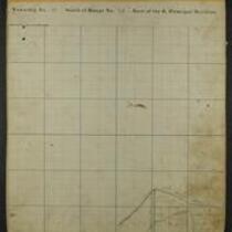
Maps of Shawnee Indian Reservation
-
Description
-
These 21 plat maps were made ca. 1857 by Isaac Cooper Stuck. The maps are marked with geographical features and locations of people’s land claims within the Shawnee Indian Reservation in eastern Kansas.
-
Object Type
-
Map
-
-
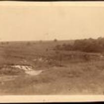
Title
-
Black Jack Battleground in Douglas County, Kansas
-
Description
-
Photograph of the site of the Black Jack battlefield near Palmyra in Douglas County, Kansas. On June 2, 1856, abolitionist John Brown and his followers attacked the forces of a proslavery settler, Henry C. Pate in the unofficial first battle of the Civil War (nearly five years prior to the war's beginning). Pate, who held two of Brown's sons captive, exchanged them for 23 prisoners after Brown and his free-state forces won the battle.
-
Object Type
-
Image
-
Date
-
December, 1888
-

-
Title
-
Sectional Map of Kansas Territory
-
Description
-
This color map, dated April 1857, is entitled "Sectional Map of Kansas Territory." It was drafted by C.P. Wiggin and signed by L.A. MacLean, Chief Clerk of the Surveyor General’s office in Lecompton, Kansas Territory. MacLean certifies that the map was compiled from U.S. survey field notes. The map was published by MacLean and Lawrence and printed by William Schuchman and Bro. in Philadelphia.
-
Object Type
-
Map
-
Date
-
April 1857
-

-
Title
-
Map Showing the Progress of the Public Surveys in the Territories of Kansas and Nebraska
-
Description
-
This black-and-white map, signed by Ward B. Burnett, Surveyor General, was issued by the Surveyor General’s office in Nebraska City, Nebraska Territory on October 1, 1858. The map depicts the progress of the public surveys in Kansas and Nebraska in 1858, and was created to accompany the Surveyor General's report of that year. The map was printed by C.B. Graham Lithographers in Washington, DC.
-
Date
-
October 1, 1858
