Error message
Notice: Trying to access array offset on value of type null in IslandoraSolrDisplayManagerResults->currentQueryDisplays() (line 222 of /var/www/drupal7/sites/all/modules/islandora_solr_display_manager/includes/islandora_solr_display_manager.inc).
-
-
Title
-
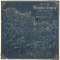
Map of Douglas County, Kansas
-
Description
-
This map of Douglas County, Kansas Territory was drawn by I. Cooper Stuck in July of 1857. The map is marked with the locations of individual people's land claims.
-
Object Type
-
Map
-
Date
-
July 1857
