Error message
Notice: Trying to access array offset on value of type null in IslandoraSolrDisplayManagerResults->currentQueryDisplays() (line 222 of /var/www/drupal7/sites/all/modules/islandora_solr_display_manager/includes/islandora_solr_display_manager.inc).
-
-
Title
-
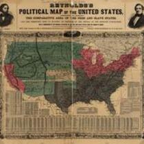
Reynolds's Political Map of the United States
-
Description
-
Printed on map: "Designed to exhibit the comparative area of the free and slave states and the territory open to slavery or freedom by the repeal of the Missouri compromise. With a comparison of the principal statistics of the free and slave states, from the census of 1850." Political map delineating the slave states, free states, and open territories, ca. 1856. The maps were created as political propaganda for the first Republican Party candidate for President, John C. Fremont, whose likeness is visible in the upper left corner of the map.
-
Object Type
-
Map
-
-
Title
-
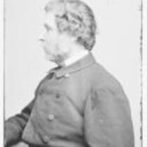
John C. Fremont
-
Description
-
Glass plate negative of military officer, explorer, and politician John C. Fremont in profile, circa 1855-1865.
-
Object Type
-
Image
-
-
Title
-
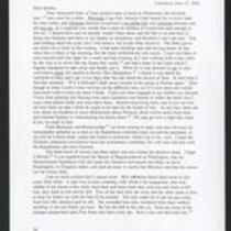
From Edward Fitch to Dear Mother
-
Description
-
Edward Fitch of Lawrence, Kansas writes a letter to his mother in Massachusetts on June 15, 1856. He voices disappointment with James Buchanan and predicts that if John C. Fremont is not elected president, Kansas will be admitted to the Union as a slave state. Yet he expresses optimism that “the death knell of slavery has been tolled.” He reports that Colonel Sumner has been gathering troops in Palmyra, Kansas, and he predicts that violence will ensue. He adds that in Lawrence, a number of Free State men have been robbed, and that “Men are being found dead more or less every little while.”
-
Date
-
June 15, 1856
