Error message
Notice: Trying to access array offset on value of type null in IslandoraSolrDisplayManagerResults->currentQueryDisplays() (line 222 of /var/www/drupal7/sites/all/modules/islandora_solr_display_manager/includes/islandora_solr_display_manager.inc).
-
-
Title
-
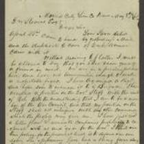
From James Montgomery to George L. Stearns
-
Description
-
James Montgomery writes a letter from Mound City, Kansas to George L. Stearns on May 8, 1861. He reports that, “We are in a perilous position here, and have not ammunition enough to make a respectable fight.” He says that he has organized a regiment to help defend Kansas against pro-slavery Missourians, whose troops are camped along the border of Linn and Bourbon counties. He mentions that an Osage Indian chief attacked some of these troops, then “tied them with ropes to the Horns of his Saddles and dragged them out of the country.” Montgomery asks for Stearns’s assistance in acquiring arms and declares that, “If we have to fight, we will carry the war out of Kansas.”
-
Date
-
May 8, 1861
-
-
Title
-
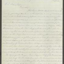
From James Montgomery to G.L. Stearns
-
Description
-
These two letters were sent to G.L. Stearns by James Montgomery. Writing from Mound City, Kansas on May 8, 1861, Montgomery states that he has organized a regiment and accepted a position on the Governor’s War Council. He reports that the Missourians are “trying to stir up the Indians on our border,” and asks Stearns for two small breech-loading guns. Writing from Lawrence, Kansas on June 21, 1861, Montgomery says that southern Kansas is threatened by invasion from Missouri and Arkansas, while Union men in Missouri are either driven out of the state or drafted into the Confederate army. Montgomery states that he has used Stearns' letter of credit at various times, and thanks him for his generosity.
-
Date
-
May 8, 1861 and June 21, 1861
-

-
Title
-
Sectional Map of Kansas Territory
-
Description
-
This color map, dated April 1857, is entitled "Sectional Map of Kansas Territory." It was drafted by C.P. Wiggin and signed by L.A. MacLean, Chief Clerk of the Surveyor General’s office in Lecompton, Kansas Territory. MacLean certifies that the map was compiled from U.S. survey field notes. The map was published by MacLean and Lawrence and printed by William Schuchman and Bro. in Philadelphia.
-
Object Type
-
Map
-
Date
-
April 1857
-

-
Title
-
New Sectional Map of Kansas
-
Description
-
This color map, drafted in 1859 by Robert L. Ream, was published by Stevenson and Morris of St. Louis, and printed by A. Janicke and Co. of St. Louis. The map is entitled “New Sectional Map of Kansas,” and was compiled from the field notes in the Surveyor General’s office.
-
Object Type
-
Map
-
Date
-
1859
-

-
Title
-
Sectional Map of the Territory of Kansas
-
Description
-
This color map, entitled “Sectional Map of the Territory of Kansas,” was compiled from the field notes in the Surveyor General’s office. It was published in 1857 by John Halsall in St. Louis.
-
Object Type
-
Map
-
Date
-
1857
-

-
Title
-
Kansas and Nebraska 1856
-
Description
-
This color map, entitled “Kansas and Nebraska 1856,” was printed by J.G. Wells in New York.
-
Object Type
-
Map
-
Date
-
1856
