Error message
Notice: Trying to access array offset on value of type null in IslandoraSolrDisplayManagerResults->currentQueryDisplays() (line 222 of /var/www/drupal7/sites/all/modules/islandora_solr_display_manager/includes/islandora_solr_display_manager.inc).
-
-
Title
-
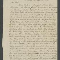
From "C." to "Col."
-
Description
-
This letter, dated September 21, 1861, is from "C." in St. Joseph, Missouri to "Col." C. reports that the Federal troops surrendered at the Battle of Lexington on September 20. He writes that "our country has been rob[b]ed by both parties . . . nearly evry body that is worth any thing has been rob[b]ed more or less, no matter what their politics are." He adds that people are "bitter" about the Platte Purchase, and predicts that fighting will ensue.
-
Date
-
September 21, 1861
-
-
Title
-
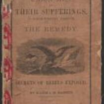
Union Men and Their Sufferings in North-Western Missouri
-
Description
-
This 1864 pamphlet, entitled “Union Men and Their Sufferings in North-Western Missouri,” was written by Major J.M. Bassett, former Provost Marshal-General of the Northwest District of Missouri. Bassett provides a “glance at the history of the Rebellion in Northwest Missouri,” admitting “it may be that my hatred for rebels is too intense, my sympathy for loyal men too strong, to make every sentence I write acceptable to all.” The pamphlet, which features several black-and-white illustrations, was published by the Press of Wynkcop, Hallenbeck, and Thomas in New York, with proceeds from its sale given to The Ladies’ Aid Society of St. Joseph, Missouri.
-
Date
-
1864
-

-
Title
-
Nebraska and Kanzas
-
Description
-
This color map, ca. 1854-1861, is entitled “Nebraska and Kanzas.” It was printed by J.H. Colton and Co. in New York.
-
Object Type
-
Map
-
Date
-
1854-1861
-

-
Title
-
Map Showing the Progress of the Public Surveys in the Territories of Kansas and Nebraska
-
Description
-
This black-and-white map, signed by Ward B. Burnett, Surveyor General, was issued by the Surveyor General’s office in Nebraska City, Nebraska Territory on October 1, 1858. The map depicts the progress of the public surveys in Kansas and Nebraska in 1858, and was created to accompany the Surveyor General's report of that year. The map was printed by C.B. Graham Lithographers in Washington, DC.
-
Date
-
October 1, 1858
