Error message
Notice: Trying to access array offset on value of type null in IslandoraSolrDisplayManagerResults->currentQueryDisplays() (line 222 of /var/www/drupal7/sites/all/modules/islandora_solr_display_manager/includes/islandora_solr_display_manager.inc).
-
-
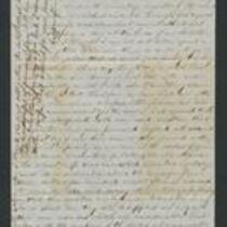
Title
-
From James Griffing to Augusta
-
Description
-
This July 9, 1855 letter was written by James Griffing at Ottawa Creek, Kansas, to Augusta. James writes that he is “travelling the rounds of another preacher’s circuit,” currently staying with an Ottawa Indian named “Jones” (possibly “Ottawa Jones”). James criticizes the Kansas-Nebraska Act and the Bogus Legislature, and describes an inspiring speech given by Charles Robinson in Lawrence, Kansas on Independence Day.
-
Date
-
July 9, 1855
-
-
Title
-
Kansas Executive Department Council Journal
-
Description
-
This excerpt from the 1855 Kansas Executive Committee Council Journal records the Council’s discussion of various proposed acts and bills. These acts and bills address topics such as coal mining, the territorial capital at Lecompton, Kansas, enacting a state census and state constitutional convention, enforcing the Fugitive Slave Law, and voting rights for American Indians. The journal also features correspondence from Andrew Reeder.
-
Object Type
-
Government Document
-
Date
-
1855
-

-
Title
-
Sectional Map of Kansas Territory
-
Description
-
This color map, dated April 1857, is entitled "Sectional Map of Kansas Territory." It was drafted by C.P. Wiggin and signed by L.A. MacLean, Chief Clerk of the Surveyor General’s office in Lecompton, Kansas Territory. MacLean certifies that the map was compiled from U.S. survey field notes. The map was published by MacLean and Lawrence and printed by William Schuchman and Bro. in Philadelphia.
-
Object Type
-
Map
-
Date
-
April 1857
-

-
Title
-
New Sectional Map of Kansas
-
Description
-
This color map, drafted in 1859 by Robert L. Ream, was published by Stevenson and Morris of St. Louis, and printed by A. Janicke and Co. of St. Louis. The map is entitled “New Sectional Map of Kansas,” and was compiled from the field notes in the Surveyor General’s office.
-
Object Type
-
Map
-
Date
-
1859
-

-
Title
-
Sectional Map of the Territory of Kansas
-
Description
-
This color map, entitled “Sectional Map of the Territory of Kansas,” was compiled from the field notes in the Surveyor General’s office. It was published in 1857 by John Halsall in St. Louis.
-
Object Type
-
Map
-
Date
-
1857
-

-
Title
-
Kansas and Nebraska 1856
-
Description
-
This color map, entitled “Kansas and Nebraska 1856,” was printed by J.G. Wells in New York.
-
Object Type
-
Map
-
Date
-
1856
