Error message
Notice: Trying to access array offset on value of type null in IslandoraSolrDisplayManagerResults->currentQueryDisplays() (line 222 of /var/www/drupal7/sites/all/modules/islandora_solr_display_manager/includes/islandora_solr_display_manager.inc).
Pages
-
-
Title
-
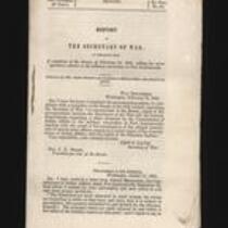
Report of the Secretary of War
-
Description
-
This is Executive Document No. 50, 2nd Session, 33rd Congress, presented to the Senate on February 14, 1855 by Secretary of War Jefferson Davis. The report contains copies of correspondence “respecting a claim advanced by the Commissioner of Indian Affairs to the military reservation at Fort Leavenworth; together with the result of his investigation of the alleged interference of certain army officers…with the rights of the Delaware Indians.”
-
Object Type
-
Government Document
-
Date
-
February 14, 1855
-
-
Title
-
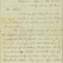
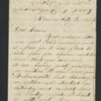
From Abishai Stowell to "Dear Sister"
-
Description
-
On October 14, 1863, Abishai Stowell writes from Springfield, Missouri to his sister. Stowell reports that he was recently home on furlough, and says the family wants to move away from their home. He thinks this is unnecessary: "Our folks live in a place where there is no danger from the Indians & but little from the Guirilas." Stowell believes that many girls are so "afraid that the men will all be killed off before this war ends...they marry men that they would not think of speaking to 4 years ago."
-
Date
-
October 14, 1863
-
![Constitutional Convention, Topeka, Kansas Territory [Topeka]](https://civilwaronthewesternborder.org/sites/civilwaronthewesternborder.org/files/styles/islandora_imagecache_image_style_medium/public/externals/be261c1645001f328b7032d00e8de879.jpg?itok=o4Mdz8vY&pid=civilwar:1311&iic=true)
-
Title
-
Constitutional Convention, Topeka, Kansas Territory [Topeka]
-
Description
-
Wood engraving depicting the Topeka Constitutional Convention of December 15, 1855. At the convention, Free-Staters voted to adopt the Topeka Constitution for Kansas Territory, provisionally banning slavery in Kansas and allowing suffrage for "civilized" male Native Americans, but still excluded blacks from settling in the state. However, the constitution failed to gain the recognition of proslavery settlers and the federal government, including President Franklin Pierce, who declared the Topeka legislature to be illegal and treasonous.
-
Object Type
-
Image
-
Date
-
December 15, 1855
-
-
Title
-
From George W. Collamore to William P. Dole
-
Description
-
This letter, dated April 21, 1862, is from George W. Collamore to Hon. William P. Dole, Commissioner of Indian Affairs. Writing from Washington, DC, Collamore provides an account of his "recent visit to the Loyal Indians who were obliged to flee from their pursuers (the rebel Indians and Texans) in the dead of Winter and are now encamped on the Neosho River" in southern Kansas. Collamore states that these Indians, numbering about 8,000, have suffered and many have died from exposure and lack of food.
-
Date
-
April 21, 1862
-
-
Title
-
From W.W. to M.
-
Description
-
On June 22, 1856, W.W. writes from Washington to "M." (possibly Matthew Walker). W.W. reports that Gen. Whitfield arrived in Washington with several other men from Kansas, who "maintained a most singular and studied reserve" when they saw him. He adds that "the Abolition members are woefully down in the mouth about the availability of Sharp's rifles in Kansas. Pomeroy, Roberts and Eldridge have arrived, but no Gov. Reeder."
-
Object Type
-
Letter
-
Date
-
June 22, 1856
-
-
Title
-
From S. Shelly to Mrs. Staples
-
Description
-
This letter, dated February 20, 1865, is from S. Shelly in Independence, Missouri to Mrs. Staples. Shelly writes that the Missouri Militia will be recruiting soldiers in the area, and "I don't suppose any one will be exempted unless they are blind in boath eys or boath arms taken off." Shelly tells Mrs. Staples that there have been cases of smallpox in the area, but mostly among "negroes and soldiers." Shelly also mentions that mail service was stopped in Denver City "on account of Indian hostilities" but will resume again under military escort.
-
Date
-
February 20, 1865
-
-
Title
-
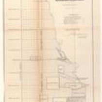
Plan of the Public Surveys in Kansas and Nebraska
-
Description
-
This black-and-white map, signed by J. Calhoun, Surveyor General of Kansas and Nebraska, was issued by the Surveyor General’s office in Wyandott, Kansas Territory on October 20, 1856. The map is entitled "Plan of the Public Surveys in Kansas and Nebraska." It was printed by Ackerman Lithographers in New York.
-
Object Type
-
Map
-
Date
-
October 20, 1856
-
-
Title
-
From Edward Fitch to Dear Parents
-
Description
-
In an April 28, 1861 letter to his parents in Massachusetts, Edward Fitch of Lawrence, Kansas declares, “did you think that you would ever live to see it—a Civil War, the most horrible of all wars.” He informs them that he has joined an artillery company. He adds that the military “is organising in large numbers” in Lawrence, but he expresses his fear that if Missouri secedes from the Union, Kansas will not have enough arms or ammunition for defense. He also expresses concern that the Cherokee and Choctaw tribes will fight for the South.
-
Date
-
April 28, 1861
-

-
Title
-
Sectional Map of Kansas Territory
-
Description
-
This color map, dated April 1857, is entitled "Sectional Map of Kansas Territory." It was drafted by C.P. Wiggin and signed by L.A. MacLean, Chief Clerk of the Surveyor General’s office in Lecompton, Kansas Territory. MacLean certifies that the map was compiled from U.S. survey field notes. The map was published by MacLean and Lawrence and printed by William Schuchman and Bro. in Philadelphia.
-
Object Type
-
Map
-
Date
-
April 1857
-

-
Title
-
Nebraska and Kanzas
-
Description
-
This color map, ca. 1854-1861, is entitled “Nebraska and Kanzas.” It was printed by J.H. Colton and Co. in New York.
-
Object Type
-
Map
-
Date
-
1854-1861
-

-
Title
-
New Sectional Map of Kansas
-
Description
-
This color map, drafted in 1859 by Robert L. Ream, was published by Stevenson and Morris of St. Louis, and printed by A. Janicke and Co. of St. Louis. The map is entitled “New Sectional Map of Kansas,” and was compiled from the field notes in the Surveyor General’s office.
-
Object Type
-
Map
-
Date
-
1859
-
-
Title
-
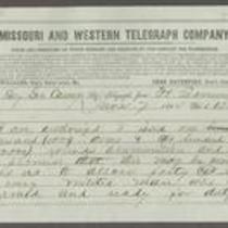
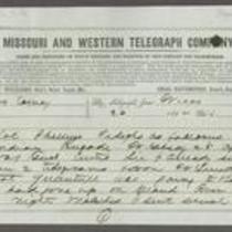
From Samuel R. Curtis to Thomas Carney
-
Description
-
This telegram, dated June 7, 1864, was sent by Maj. Gen. Samuel R. Curtis at Fort Leavenworth, Kansas, to Kansas Gov. Thomas Carney. Curtis states that he has been authorized to issue 1,000 arms and 200,000 rounds of ammunition to the militia. He tells Curtis that “Bushwhackers are east & south of us and hostile thieving indians west but with great vigilance on the part of federal & state troops we may protect the settlement.”
-
Object Type
-
Telegram
-
Date
-
June 7, 1864
-

-
Title
-
Sectional Map of the Territory of Kansas
-
Description
-
This color map, entitled “Sectional Map of the Territory of Kansas,” was compiled from the field notes in the Surveyor General’s office. It was published in 1857 by John Halsall in St. Louis.
-
Object Type
-
Map
-
Date
-
1857
-
-
Title
-
From Unknown to Thomas Carney
-
Description
-
This telegram was sent from Fort Leavenworth, Kansas to Kansas Gov. Thomas Carney on April 26, 1864. The telegram consists of an April 23, 1864 telegraph communication between Col. Phillips and Major General S.R. Curtis. Phillips informs Curtis that his troops are tracking Quantrill’s movements through Kansas along the Arkansas River, and that one of his companies stationed near the river may meet Quantrill soon. Curtis replies that from Phillips’ telegram, he infers Quantrill’s location to be on the southern side of the Arkansas.
-
Object Type
-
Telegram
-
Date
-
April 26, 1864
-
-
Title
-
From Fred to Dear Cousins
-
Description
-
This February 28, 1862 letter is from a soldier named Fred to his cousins. He reports that he just marched from Fort Leavenworth, Kansas with Company A, to Kansas City, Missouri, where they are guarding Fort Union against the Jayhawkers. He tells his cousins that the 2nd Battalion of his regiment "had a brush with the rebels at Independence," and adds that he may be marching to St. Louis soon.
-
Date
-
February 28, 1862
-

-
Title
-
Kansas and Nebraska 1856
-
Description
-
This color map, entitled “Kansas and Nebraska 1856,” was printed by J.G. Wells in New York.
-
Object Type
-
Map
-
Date
-
1856
-

-
Title
-
Map Showing the Progress of the Public Surveys in the Territories of Kansas and Nebraska
-
Description
-
This black-and-white map, signed by Ward B. Burnett, Surveyor General, was issued by the Surveyor General’s office in Nebraska City, Nebraska Territory on October 1, 1860. The map shows the progress of the public surveys in the territories of Kansas and Nebraska, and was produced to accompany the Surveyor General’s 1860 annual report.
-
Object Type
-
Map
-
Date
-
October 1, 1860
-

-
Title
-
Map Showing the Progress of the Public Surveys in the Territories of Kansas and Nebraska
-
Description
-
This black-and-white map, signed by Ward B. Burnett, Surveyor General, was issued by the Surveyor General’s office in Nebraska City, Nebraska Territory on October 1, 1859. The map shows the progress of the public surveys in the territories of Kansas and Nebraska, and was produced to accompany the Surveyor General’s 1859 annual report.
-
Object Type
-
Map
-
Date
-
October 1, 1859
-

-
Title
-
Map Showing the Progress of the Public Surveys in Kansas and Nebraska
-
Description
-
This black-and-white map, signed by Mark W. Delahay, Surveyor General, was issued by the Surveyor General’s office in Leavenworth, Kansas on September 2, 1861. The map shows the progress of the public surveys in Kansas and Nebraska, and was produced to accompany the Surveyor General’s report of 1861.
-
Object Type
-
Map
-
Date
-
September 2, 1861
-

-
Title
-
Sketch of the Public Surveys in Kansas and Nebraska
-
Description
-
This black-and-white map, signed by J. Calhoun, Surveyor General, was issued by the Surveyor General’s office in Wyandott, Kansas Territory on November 8, 1856. The map is entitled “Sketch of the Public Surveys in Kansas and Nebraska.” It was printed by A. Hoen and Co. in Baltimore.
-
Object Type
-
Map
-
Date
-
November 8, 1855
Pages
