Error message
Notice: Trying to access array offset on value of type null in IslandoraSolrDisplayManagerResults->currentQueryDisplays() (line 222 of /var/www/drupal7/sites/all/modules/islandora_solr_display_manager/includes/islandora_solr_display_manager.inc).
-
-
Title
-
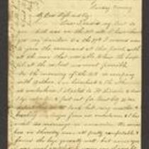
From A.J. Huntoon to My Dear Wife and Boy
-
Description
-
This letter, dated October 6, 7, 10, and 11, 1861, is from A.J. Huntoon to his wife Lizzie and son Prentice. Huntoon, a member of the 5th Kansas Cavalry volunteer regiment, tells his family that he was ordered to take charge of a military hospital in Mapleton, Bourbon County, Kansas. He estimates that there are 50,000-55,000 Union soldiers in Missouri, including the companies of Generals Sturgis, Siegel, and Fremont, and that there are about 70,000 Confederate troops in Missouri under the commandment of Generals McCulloch and Rains. Huntoon predicts that “We will have a big battle in this vicinity ere so long.”
-
Date
-
October 6, 1861-October 11, 1861
-
-
Title
-
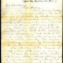
From Robert M. Stewart to Samuel Medary
-
Description
-
This letter, dated December 31, 1858, is from Missouri Gov. Robert M. Stewart to Kansas Gov. Samuel Medary. Stewart reports a recent invasion by James Montgomery and his “band of marauders” and says that he has received a request to send an officer to the border to capture armed men and prevent Montgomery from escaping. Stewart also informs Medary that the Missouri General Assembly is in session and will discuss preventing further invasions and bringing the guilty to justice.
-
Object Type
-
Government Document
-
Date
-
December 31, 1858
-

-
Title
-
Sectional Map of Kansas Territory
-
Description
-
This color map, dated April 1857, is entitled "Sectional Map of Kansas Territory." It was drafted by C.P. Wiggin and signed by L.A. MacLean, Chief Clerk of the Surveyor General’s office in Lecompton, Kansas Territory. MacLean certifies that the map was compiled from U.S. survey field notes. The map was published by MacLean and Lawrence and printed by William Schuchman and Bro. in Philadelphia.
-
Object Type
-
Map
-
Date
-
April 1857
-

-
Title
-
New Sectional Map of Kansas
-
Description
-
This color map, drafted in 1859 by Robert L. Ream, was published by Stevenson and Morris of St. Louis, and printed by A. Janicke and Co. of St. Louis. The map is entitled “New Sectional Map of Kansas,” and was compiled from the field notes in the Surveyor General’s office.
-
Object Type
-
Map
-
Date
-
1859
-

-
Title
-
Map Showing the Progress of the Public Surveys in the Territories of Kansas and Nebraska
-
Description
-
This black-and-white map, signed by Ward B. Burnett, Surveyor General, was issued by the Surveyor General’s office in Nebraska City, Nebraska Territory on October 1, 1860. The map shows the progress of the public surveys in the territories of Kansas and Nebraska, and was produced to accompany the Surveyor General’s 1860 annual report.
-
Object Type
-
Map
-
Date
-
October 1, 1860
-

-
Title
-
Map Showing the Progress of the Public Surveys in the Territories of Kansas and Nebraska
-
Description
-
This black-and-white map, signed by Ward B. Burnett, Surveyor General, was issued by the Surveyor General’s office in Nebraska City, Nebraska Territory on October 1, 1859. The map shows the progress of the public surveys in the territories of Kansas and Nebraska, and was produced to accompany the Surveyor General’s 1859 annual report.
-
Object Type
-
Map
-
Date
-
October 1, 1859
-

-
Title
-
Map Showing the Progress of the Public Surveys in the Territories of Kansas and Nebraska
-
Description
-
This black-and-white map, signed by J. Calhoun, Surveyor General, was issued by the Surveyor General’s office in Lecompton, Kansas Territory in October 1857. The map shows the progress of the public surveys in the territories of Kansas and Nebraska, and was produced to accompany the Surveyor General’s 1857 annual report.
-
Date
-
October 1857
